1910s Maps of Arizona
Explore 30 historic maps of Arizona from the 1910s. These maps offer a rare glimpse into what life looked like during the 1910s — showing old roads, neighborhoods, homes, and landmarks that have changed or disappeared over time.
Whether you're researching your family's past, planning a metal detecting trip, or studying how Arizona's landscape evolved across the 1910s, these high-resolution maps are a powerful tool for exploring the history of this region.
- Focus on a specific era: All maps on this page are from the 1910s, giving you a focused view of this time period.
- See what’s changed: Compare century-old streets, trails, and buildings to today's modern landscape using overlays and satellite layers.
- Research with precision: Use these maps for genealogy, historical research, land use analysis, or educational projects.
- View, download, or print: Maps are fully viewable online in high resolution, and can be downloaded or printed for your own records.
Start exploring Arizona's history through authentic maps from the 1910s. This is your window into the past.
Arizona maps
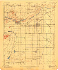
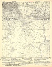
(30)- 1910 Map of Bisbee
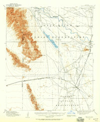
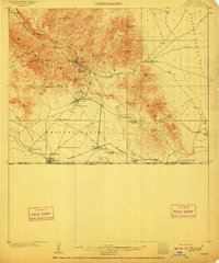 1910 Bisbee1910 Print · USGSMining and ranching define this Cochise County landscape in the early 1900s as Bisbee booms in the Mule Mountains. Researchers can trace the El Paso and Southwestern RR past Don Luis to the border at Naco, identifying family ranch sites like Browns Ranch and Forrests Ranch along the way.2 unique versions available
 - 1910 Map of Ray
 1910 Ray1910 Print · USGSArizona's copper country and Gila River basin are captured here at a peak of early industrial expansion. Genealogy researchers can locate early homesteads like Uncle Dan's Ranch and Winkelman's Ranch, alongside the massive Ray Mine and the Phoenix and Eastern R. R. corridor.3 unique versions available
 - 1911 Map of Parker
 1911 Parker1911 Print · USGSThe Arizona-California borderlands are captured here in the early twentieth century as the river and rail networks began to transform the desert. Researchers can trace the development of the Colorado River Indian Reservation, the rail hub at Parker, and early mining sites like the Billy Mack Mine.3 unique versions available
 - 1911 Map of Winkelman, 1957 Print
 1911 Winkelman1957 Print · USGSThe Pinal and Pima County line comes alive in the 1910s, showing a landscape of mining camps and early ranching. Genealogists and historians can trace the foundations of Mammoth and find long-lost sites like the Finch School, Campo Bonito, and the MAMMOTH MINE.
 - 1912 Map of Flagstaff
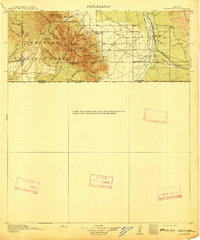
 1912 Flagstaff1912 Print · USGSFlagstaff and the surrounding Coconino highlands appear here during a period of steady growth along the railroad. Genealogists and historians can locate early family sites like Darden's Ranch, the Lowell Observatory, and Greenlaw's Mill.5 unique versions available
 - 1912 Map of Petrified Forest
 1912 Petrified Forest1912 Print · USGSArizona's high desert was a remote frontier of fossils and rail travel just after the turn of the century. Genealogists and historians can trace early outposts like Adamana and Ortegas Ranch or locate archeological sites such as Indian Ruins and The Pictographs.2 unique versions available
 - 1912 Map of Roosevelt
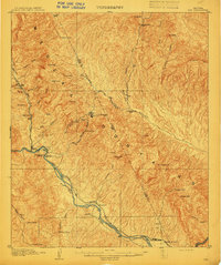
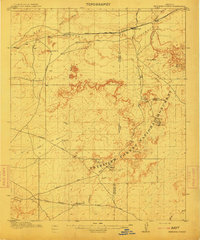
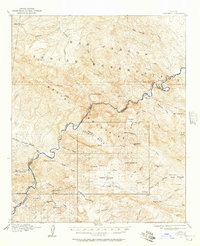
 1912 Roosevelt1912 Print · USGSCentral Arizona is captured here during the transformative years following the completion of the Roosevelt Dam. You can trace early ranching homesteads such as Clines Ranch and Howell's Ranch or locate the site of Schell's Station.4 unique versions available
 - 1912 Map of Phoenix, 1955 Print
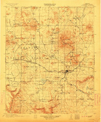
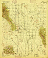
 1912 Phoenix1955 Print · USGSEarly 1900s Phoenix is depicted as an emerging agricultural and rail hub defined by its extensive canal system and desert surroundings. Genealogists and local researchers can trace early homesteads and community centers like Alhambra, St Johns Chapel, and the County Poor Farm.
 - 1913 Map of Winkelman
 1913 Winkelman1913 Print · USGSThe confluence of the Gila and San Pedro rivers in the 1910s reveals a landscape of mining camps and remote ranching outposts. Trace the early industrial footprint of the Mammoth Mine and Oracle or find family landmarks like Finch School and Biddicks Cabin.4 unique versions available
 - 1913 Map of Morenci, 1954 Print
 1913 Morenci1954 Print · USGSArizona's copper country and high timberlands meet in this pre-war survey of the Morenci district and Apache National Forest. Researchers can trace the early industrial footprint of Morenci and Clifton or find family landmarks like Miller Cabin and Cooks Ranch.2 unique versions available
 - 1913 Map of Mesa, 1955 Print
 1913 Mesa1955 Print · USGSMaricopa County's irrigation and early rail networks are meticulously detailed in this pre-war survey of the Salt River Valley. Genealogists can trace family names at local landmarks like Alma School, the settlement of Creamery, and the Kyrene School.
 - 1913 Map of Maricopa, 1958 Print
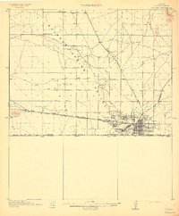
 1913 Maricopa1958 Print · USGSArizona's desert interior comes to life in this early twentieth-century survey of the Gila River Valley. Researchers can trace the shifting rail lines through Maricopa and locate the historic site of Maricopa Wells (Abandoned) or Pima Village.
 - 1914 Map of Hereford
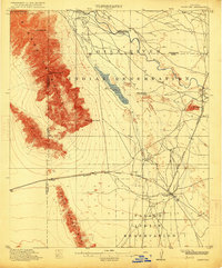
 1914 Hereford1914 Print · USGSUpper Cochise County reveals its early ranching and mining character just before the Great War. Genealogists and historians can trace remote mountain settlements like Sunnyside and Hamburg or the railway path of the El Paso and Southwestern.3 unique versions available
 - 1914 Map of Gila Butte
 1914 Gila Butte1914 Print · USGSThe Gila River valley in the early twentieth century shows a landscape defined by desert trading posts and the rise of managed irrigation. Researchers can locate family roots and early commerce at the Sweetwater Store Indian Trading Post, Snaketown, and the Casa Blanca Indian School.
 - 1914 Map of Douglas
 1914 Douglas1914 Print · USGSThe copper-smelting industry dominates the landscape near the international border just before the Great War. Genealogists and historians can trace the early foundations of Douglas, the grid of Pirtleville, and rural landmarks like Carey Ranch and Valley School.3 unique versions available
 - 1914 Map of Phoenix
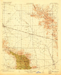
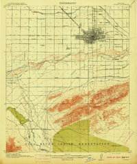 1914 Phoenix1914 Print · USGSPhoenix and its surrounding valley are documented here at a pivotal moment of irrigation-driven growth before the mid-century boom. Genealogists and historians can locate early landmarks like the State Hospital, Maricopa Village, and numerous rural schoolhouses such as Isaac School and Fowler School.4 unique versions available
 - 1915 Map of Mesa
 1915 Mesa1915 Print · USGSMaricopa County's agricultural heartland was defined by a complex web of gravity-fed water systems before the era of modern expansion. Genealogists and historians can trace early settlements and school districts like Kyrene School, Falfa, and the Arizona State Normal School.2 unique versions available
 - 1915 Map of Benson
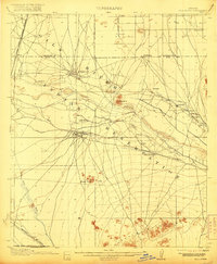
 1915 Benson1915 Print · USGSSouthern Arizona was a landscape of rail junctions and mining claims just before the Great War. Genealogists and historians can trace the reach of Tombstone, find the Panama Mine, and locate vanished rail stops like Fairbank and Boquillas.4 unique versions available
 - 1915 Map of Maricopa
 1915 Maricopa1915 Print · USGSThe Gila River Valley and its early twentieth-century reservations are captured here as the railroad began to redefine Arizona's desert hubs. Genealogists and historians can trace old stops like Maricopa Wells (Abandoned), the rail junction at Maricopa, and the peaks of the Sierra Estrella.2 unique versions available
 - 1915 Map of Morenci
 1915 Morenci1915 Print · USGSGreenlee County during the early 1900s shows a landscape defined by industrial copper mining and isolated high-desert ranching. Genealogists and historians can trace family locations from the Eagle Creek School to historic homesteads like Dudley Ranch and the settlement of Oroville.3 unique versions available
 - 1915 Map of Christmas, 1957 Print
 1915 Christmas1957 Print · USGSThe Gila River canyon and Mescal Mountains are shown here during the peak of early Arizona mining and ranching. Genealogists and historians can trace the foundations of the Christmas settlement, the Arizona Eastern rail line, and remote sites like Mings Ranch or the Lower Coal Field Mine.2 unique versions available
 - 1916 Map of Pearce
 1916 Pearce1916 Print · USGSCochise County mining camps and ranch lands are documented here during the peak of the copper boom. Researchers can trace family-named outposts like Kirkpatrick Ranch or locate early rural education sites such as Stronghold School and Brophy School.3 unique versions available
 - 1916 Map of Douglas
 1916 Douglas1916 Print · USGSThe Arizona-Mexico border comes alive in the mid-1910s, showcasing the height of the copper mining era around Bisbee and Douglas. Genealogists and historians can trace family land like Forrests Ranch and local institutions like the Double Adobe Valley School.
 - 1917 Map of Gila Butte
 1917 Gila Butte1917 Print · USGSThe Pinal County desert comes into focus during the early twentieth century as irrigation and rail lines began to reshape the Gila River valley. Genealogists and historians can locate early trading hubs like the North Line Trading Post and tribal landmarks including Snaketown and the Casa Blanca Indian School.2 unique versions available
 - 1917 Map of San Simon
 1917 San Simon1917 Print · USGSArizona and New Mexico ranching and rail history meet here during the years following the border surveys. Genealogists and historians can locate remote family sites like Posey Ranch, the historical Old Fort Bowie, and early copper or granite works at Willie Rose Mine.3 unique versions available
Showing maps 1-25 of 30
Top cities of Arizona
- Phoenix historical maps
- Tucson historical maps
- Mesa historical maps
- Chandler historical maps
- Glendale historical maps
- Scottsdale historical maps
See more
Top counties of Arizona
- Maricopa County historical maps
- Pima County historical maps
- Pinal County historical maps
- Yavapai County historical maps
- Mohave County historical maps
- Coconino County historical maps
See more
Frequently asked questions
- What are the different types of historical maps available for Arizona?
- What is the oldest map of Arizona?
- Where can I purchase historical maps of Arizona for my home or office?
- Where can I download high-res historical maps of Arizona?
- Are there historical topographic maps available for Arizona?
- Is there historical aerial imagery available for Arizona?
- Where are historical maps of Arizona sourced from?