1930s Maps of Arizona
Explore 43 historic maps of Arizona from the 1930s. These maps offer a rare glimpse into what life looked like during the 1930s — showing old roads, neighborhoods, homes, and landmarks that have changed or disappeared over time.
Whether you're researching your family's past, planning a metal detecting trip, or studying how Arizona's landscape evolved across the 1930s, these high-resolution maps are a powerful tool for exploring the history of this region.
- Focus on a specific era: All maps on this page are from the 1930s, giving you a focused view of this time period.
- See what’s changed: Compare century-old streets, trails, and buildings to today's modern landscape using overlays and satellite layers.
- Research with precision: Use these maps for genealogy, historical research, land use analysis, or educational projects.
- View, download, or print: Maps are fully viewable online in high resolution, and can be downloaded or printed for your own records.
Start exploring Arizona's history through authentic maps from the 1930s. This is your window into the past.
Arizona maps
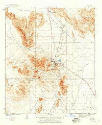
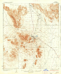
(43)- 1930 Map of Aguila Mountains
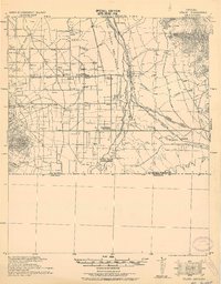
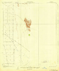 1930 Aguila Mountains1930 Print · USGSIn the Yuma County desert during the late 1920s, this survey captures a landscape of extreme verticality and open space. Researchers can trace early desert transit along the Yager Road or study the terrain surrounding the Aguila Mountains and Aztec Hills.3 unique versions available
 - 1930 Map of Linskey
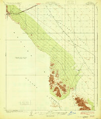
 1930 Linskey1930 Print · USGSArizona's western desert frontier comes into focus in this late 1920s survey of the La Posa Plain. Researchers can trace the path of the Atchison Topeka and Santa Fe railroad through Linskey and locate early water sources like Tenmile Well.2 unique versions available
 - 1930 Map of Stoval
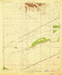 1930 Stoval1930 Print · USGSYuma County during the late twenties reveals a desert landscape organized around the Southern Pacific railroad and the Gila River. Genealogists and historians can locate old stops and sidings like Kofa Sta, Le Sage, and Stoval along the historic Old Palomas Yuma Road.4 unique versions available
 - 1930 Map of Hyder
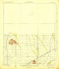 1930 Hyder1930 Print · USGSArid desert landscapes in Yuma County are captured here just before the 1930s, showing a critical crossroads for early rail and road travel. Genealogists and historians can trace the Southern Pacific line through Hyder and locate early landmarks like Morris Ranch and Hall Well.3 unique versions available
 - 1930 Map of Cave Creek, 1959 Print
 1930 Cave Creek1959 Print · USGSThe Cave Creek and Verde River backcountry comes alive in this survey from the era of guest ranches and remote outposts. Researchers can locate early family homesteads like Lewis Ranch, trace the route to the Mormon Girl Mine, or find the original Spur Cross Dude Ranch.2 unique versions available
 - 1931 Map of Kim
 1931 Kim1931 Print · USGSYuma County’s desert corridor appears here during the early thirties, defined by the isolated railroad stop at Kim. Researchers can trace the early desert travel routes like Yager Road and locate critical historic water stops such as Pimoria Well and White Well.3 unique versions available
 - 1931 Map of Moon Mtn, 1955 Print
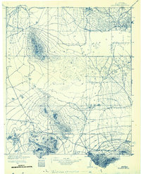
 1931 Moon Mtn1955 Print · USGSThe Arizona-California borderlands are captured here in the early thirties, defined by the winding Colorado River and the stark Dome Rock Mountains. Historians and prospectors can trace mineral workings at the Valenzuella Mine and Mammoth Mine.2 unique versions available
 - 1932 Map of Stark
 1932 Stark1932 Print · USGSThe Arizona-Sonora borderlands come alive in this early 1930s survey, documenting the ranches and rail stops along the San Pedro River. Genealogists and historians can trace family locations at Radcliffe, Hereford, and the Canton Ranch.
 - 1932 Map of Fairbank
 1932 Fairbank1932 Print · USGSCochise County during the early 1930s remains a critical hub of Arizona mining and ranching along the San Pedro River. Researchers can trace the industrial landscape of Tombstone, locating the Bronco Mine, the Powder Magazine, and old rail junctions like Benson Junction.
 - 1932 Map of Moon Mtn
 1932 Moon Mtn1932 Print · USGSThe Arizona-California borderlands are captured here in the early 1930s, showing the intersection of tribal lands and desert mining. Genealogists and historians can trace the early boundaries of the Colorado River Indian Reservation and locate industrial sites like the Valenzuela Mine.2 unique versions available
 - 1932 Map of Lochiel
 1932 Lochiel1932 Print · USGSThe Arizona-Mexico borderlands come alive in this early 1930s survey of the high desert and San Rafael Valley. Researchers can trace family ranching legacies at Stevensons Ranch or explore the mining history of The Mowry Mine and Harshaw.2 unique versions available
 - 1932 Map of Elgin
 1932 Elgin1932 Print · USGSSanta Cruz County ranching culture is on full display in the early 1930s as the Southern Pacific rail line winds through the high desert. Genealogists can trace family landmarks like Gardner's Ranch and Turner-Bower Ranch or locate the site of Old Ft Crittenden.
 - 1932 Map of Ajo, 1958 Print
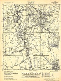
 1932 Ajo1958 Print · USGSThe copper-rich Arizona desert comes alive in the early 1930s, centered on the massive pit and surrounding worker communities. Trace the rail lines of the Tucson Cornelia and Gila Bend RR or locate the historic Indian Cem and New Cornelia Mines.
 - 1932 Map of Camp Verde, 1959 Print
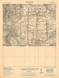
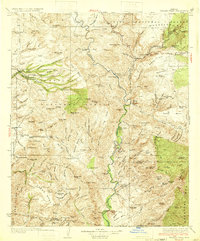
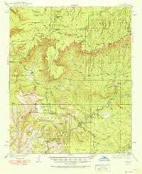
 1932 Camp Verde1959 Print · USGSThe Verde Valley and the Mogollon Rim are documented here in the early 1930s, showing a landscape of remote cattle ranches and historic ruins. Researchers can trace early schools and homesteads like Red Rock Sch, Middle Verde, and Indian Gardens alongside Montezuma Well.2 unique versions available
 - 1933 Map of Cunningham Mtn
 1933 Cunningham Mtn1933 Print · USGSThe Arizona-California borderlands were a hub of mining and early desert transit during the early 1930s. Researchers can trace the path of the Route No. 60 Sunkist Trail and locate remote operations like the Cinnabar Mine and Beamer Well.4 unique versions available
 - 1933 Map of Calabasas
 1933 Calabasas1933 Print · USGSNogales and the Santa Cruz River valley are shown here in the 1930s, documenting a critical era of border history and ranching. Trace early landmarks like Camp Stephen D. Little, the 3R Mine, and historic family lands at Buena Vista Ranch.2 unique versions available
 - 1933 Map of Turret Peak
 1933 Turret Peak1933 Print · USGSArizona's central highlands come alive in the 1930s as a land of remote mining claims and isolated ranching outposts. Trace the early copper industry at the Copper Queen Mine and Rosalie Mine, or locate family sites like the Dugan Ranch and Dugas near the Verde River.3 unique versions available
 - 1933 Map of Douglas
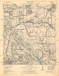
 1933 Douglas1933 Print · USGSThe borderlands of Cochise County come alive in the early thirties, showcasing a landscape defined by massive copper smelters and the bustling town of Douglas. Genealogists can trace family holdings from the Copper Queen Ranch to Valley School and identify early landmarks like Camp Harry J Jones.
 - 1933 Map of Bisbee
 1933 Bisbee1933 Print · USGSThe Arizona borderlands were a hub of copper mining and ranching during the early 1930s. Genealogists and historians can trace family-named sites like Herrons Ranch and Forrests Ranch alongside industrial landmarks like the Glance Mine.
 - 1934 Map of Tucson Mountains
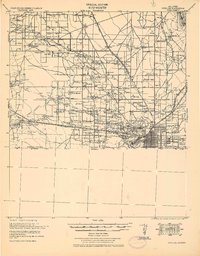
 1934 Tucson Mountains1934 Print · USGSThe desert northwest of Tucson comes into focus during the mid-1930s, showing the early footprints of the Papago Indian Reservation and the railroad corridor. Genealogists and historians can trace family-named sites and ranching outposts like Maisi Ayra Ranch, Rodriguez, and the Maish Roadside Mine.
 - 1934 Map of Ajo
 1934 Ajo1934 Print · USGSArizona's copper mining heartland comes into focus in the 1930s as industrial development expands across the desert. Genealogists and historians can trace local life at Mexican Town, locate the Indian Cem, or follow the Old Sonoita Road past remote sites like Bates Well.2 unique versions available
 - 1934 Map of Pine
 1934 Pine1934 Print · USGSIn the mid-1930s, the dramatic Mogollon Rim divided Arizona's high timberlands from the rugged canyon country. Genealogists and historians can trace early mountain life through the Crackerjack Mine, the Natural Bridge, and the Chase Ranch.2 unique versions available
 - 1934 Map of Silver Bell
 1934 Silver Bell1934 Print · USGSPima County at the height of the New Deal era reveals a sparse network of desert settlements and remote mines. Genealogists and historians can trace the footprint of the Papago Indian Reservation through its small villages like Santa Cruz and industrial sites like the Roadside Mine.
 - 1934 Map of Newman Peak
 1934 Newman Peak1934 Print · USGSThe Pinal and Pima County line area is captured here in the mid-1930s, showing a desert landscape shaped by mining and the railroad. Researchers can trace the Southern Pacific line through Redrock or locate the Sasco Mine and 96 Ranch.
 - 1934 Map of Trigo Peaks
 1934 Trigo Peaks1934 Print · USGSThe arid reaches of western Arizona appear as they were in the early thirties, during the height of desert surveying. Trace the historical Cibola Road past the Tweed Mine and through the rugged Felipe Pass.
Showing maps 1-25 of 43
Top cities of Arizona
- Phoenix historical maps
- Tucson historical maps
- Mesa historical maps
- Chandler historical maps
- Glendale historical maps
- Scottsdale historical maps
See more
Top counties of Arizona
- Maricopa County historical maps
- Pima County historical maps
- Pinal County historical maps
- Yavapai County historical maps
- Mohave County historical maps
- Coconino County historical maps
See more
Frequently asked questions
- What are the different types of historical maps available for Arizona?
- What is the oldest map of Arizona?
- Where can I purchase historical maps of Arizona for my home or office?
- Where can I download high-res historical maps of Arizona?
- Are there historical topographic maps available for Arizona?
- Is there historical aerial imagery available for Arizona?
- Where are historical maps of Arizona sourced from?