1960s Maps of Cochise County, Arizona
Explore 6 historic maps of Cochise County from the 1960s. These maps offer a rare glimpse into what life looked like during the 1960s — showing old roads, neighborhoods, homes, and landmarks that have changed or disappeared over time.
Whether you're researching your family's past, planning a metal detecting trip, or studying how Cochise County's landscape evolved across the 1960s, these high-resolution maps are a powerful tool for exploring the history of this region.
- Focus on a specific era: All maps on this page are from the 1960s, giving you a focused view of this time period.
- See what’s changed: Compare century-old streets, trails, and buildings to today's modern landscape using overlays and satellite layers.
- Research with precision: Use these maps for genealogy, historical research, land use analysis, or educational projects.
- View, download, or print: Maps are fully viewable online in high resolution, and can be downloaded or printed for your own records.
Start exploring Cochise County's history through authentic maps from the 1960s. This is your window into the past.
Cochise County, AZ maps
(6)- 1961 Map of Douglas
 1961 Douglas1961 Print · USGSThe Arizona-Mexico borderlands come into focus at mid-century, detailing the vital mining and ranching hubs of Cochise County and southwest New Mexico. Genealogists and historians can trace the Southern Pacific Railroad through Bisbee and Douglas, or locate early sites like the Old Hachita Mine and Rucker School.
 - 1962 Map of Silver City
 1962 Silver City1962 Print · USGSThe high desert borderlands of New Mexico and Arizona come alive in this early sixties survey. Genealogists and historians can trace the mining economy through the Chino Mine, follow the rail routes of the Southern Pacific, or locate settlements like Virden and Bayard.
 - 1962 Map of Tucson
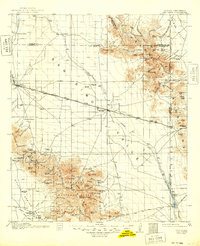
 1962 Tucson1962 Print · USGSSouthern Arizona in the early sixties showcases a landscape defined by burgeoning desert cities and massive military installations. Researchers can trace tribal settlements like Schuchk, legacy mining sites at Silver Bell Mine, and the early footprint of Davis-Monthan Air Force Base.
 - 1962 Map of San Simon, 1971 Print
 1962 San Simon1971 Print · USGSThe Arizona-New Mexico borderlands come alive in this survey of the San Simon Valley and the Peloncillo Mountains as they appeared before the Great War. Genealogists and historians can trace the foundations of Old Fort Bowie, the SOUTHERN PACIFIC line, and family landmarks like Riggs Home Ranch.
 - 1964 Map of Tucson
 1964 Tucson1964 Print · USGSSouthern Arizona in the mid-1960s shows a landscape of burgeoning desert cities and industrial-scale copper mining. Researchers can trace the development of Tucson and its outlying mining districts, including the Silver Bell Mine and San Manuel Mine.
 - 1964 Map of Douglas
 1964 Douglas1964 Print · USGSThe Arizona-New Mexico borderlands in the early sixties reveal a landscape of deep-rooted copper mining and high-desert ranching. Genealogists and researchers can trace the legacy of settlements like Pirtleville, the industrial site of the Copper Smelter, and remnants of the Cochise Mines.
End of results
Showing maps 1-6 of 6
Top cities of Cochise County
- Sierra Vista historical maps
- Douglas historical maps
- Bisbee historical maps
- Benson historical maps
- Willcox historical maps
- Whetstone historical maps
See more
Frequently asked questions
- What are the different types of historical maps available for Cochise County?
- What is the oldest map of Cochise County?
- Where can I purchase historical maps of Cochise County for my home or office?
- Where can I download high-res historical maps of Cochise County?
- Are there historical topographic maps available for Cochise County?
- Is there historical aerial imagery available for Cochise County?
- Where are historical maps of Cochise County sourced from?