1930s Maps of Colorado
Explore 30 historic maps of Colorado from the 1930s. These maps offer a rare glimpse into what life looked like during the 1930s — showing old roads, neighborhoods, homes, and landmarks that have changed or disappeared over time.
Whether you're researching your family's past, planning a metal detecting trip, or studying how Colorado's landscape evolved across the 1930s, these high-resolution maps are a powerful tool for exploring the history of this region.
- Focus on a specific era: All maps on this page are from the 1930s, giving you a focused view of this time period.
- See what’s changed: Compare century-old streets, trails, and buildings to today's modern landscape using overlays and satellite layers.
- Research with precision: Use these maps for genealogy, historical research, land use analysis, or educational projects.
- View, download, or print: Maps are fully viewable online in high resolution, and can be downloaded or printed for your own records.
Start exploring Colorado's history through authentic maps from the 1930s. This is your window into the past.
Colorado maps
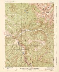
(30)- 1930 Map of Glenwood Springs
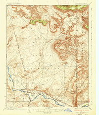
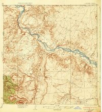
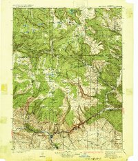 1930 Glenwood Springs1930 Print · USGSGlenwood Springs and the Colorado River corridor are captured here during the late prohibition era, showing the region's transition into a center for power and rail transport. Researchers can trace the Denver and Rio Grande Western Railroad to Dotsero or find remote outposts like Hip Roof Cabin and Transfer Springs Ranger Sta.4 unique versions available
 - 1932 Map of Savery
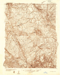
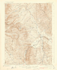
 1932 Savery1932 Print · USGSSouthern Wyoming ranching and mining country meet at the edge of the Rockies in the early thirties. Genealogists and historians can locate rural schools like Ketchum Sch, the operations of Pioneer Coal Co, and the remote Tullis settlement.3 unique versions available
 - 1933 Map of Mt. Powell
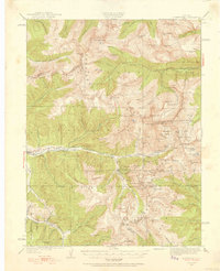
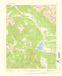
 1933 Mt. Powell1933 Print · USGSThe Colorado high country in the early thirties reveals a landscape of isolated mountain homesteads and remote federal forest lands. Genealogists and local historians can trace family locations like the Noonen Ranch or locate early rural schools including Upper Sheephorn Sch and Lakeside Sch.5 unique versions available
 - 1933 Map of Montezuma, 1956 Print
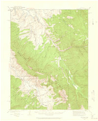
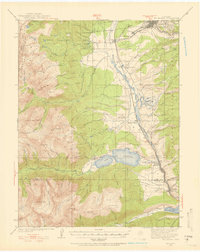
 1933 Montezuma1956 Print · USGSThe mining districts of the high Rockies are caught in a period of transition in the 1930s. Researchers can locate remote industrial sites like the Waldorf Mine and follow early mountain routes over Loveland Pass and Argentine Pass.3 unique versions available
 - 1933 Map of Ute Peak, 1959 Print
 1933 Ute Peak1959 Print · USGSThe high mountain country of Grand and Summit Counties is captured here in the early 1930s before modern development altered these drainages. Genealogists and historians can trace the locations of the Ute Park School and Hermosa School or find the remote Leal post office and Horseshoe Ranger Station.3 unique versions available
 - 1934 Map of Climax
 1934 Climax1934 Print · USGSThe Colorado high country in the mid-1930s reveals a landscape of industrial mining and high-altitude transport. Trace the routes of the Colorado and Southern RR or locate the historic mining district of Quartzville and the London Mine.
 - 1934 Map of Colorado National Monument
 1934 Colorado National Monument1934 Print · USGSMesa County was beginning to see the formalization of its famous canyonlands in the mid-1930s. You can trace early park infrastructure near Park Headquarters and follow the original switchbacks of the Serpents Trail past the Coke Ovens.
 - 1934 Map of Minturn
 1934 Minturn1934 Print · USGSThe mountain corridors of Eagle County were defined by mining and the railroad during the early nineteen-thirties. You can trace the industrial landscape of the Eagle River through settlements like Gilman, the remote Bells Camp, and the high-altitude Liberty Mine.5 unique versions available
 - 1934 Map of Dillon
 1934 Dillon1934 Print · USGSDillon and the surrounding Blue River Valley are shown here in the mid-1930s before the valley was flooded for reservoir construction. Genealogists and historians can trace the original locations of Dillon, the Dickey Ranger Sta, and mining sites like the Boss Mine.3 unique versions available
 - 1934 Map of Taylor Park, 1959 Print
 1934 Taylor Park1959 Print · USGSGunnison County high country in the mid-1930s reveals a landscape of industrial mining and remote ranching. Genealogists and historians can trace family-named sites like Gandy Ranch and Brown Ranch, or locate workings at Pieplant Mine and Star Mine.3 unique versions available
 - 1934 Map of Chimney Rock, 1967 Print
 1934 Chimney Rock1967 Print · USGSThe Navajo and Southern Ute borders met along the San Juan River in the mid-1930s, creating a crossroads of tribal administration and desert agriculture. Genealogists and historians can locate the Shiprock Indian Agency, the Agency Coal Mine, and the path of the Old Mormon Trail.
 - 1934 Map of Rattlesnake, 1971 Print
 1934 Rattlesnake1971 Print · USGSThe San Juan River basin and the Four Corners intersection are captured here in the mid-1930s. Researchers can trace the early road networks and small settlements of the Navajo Indian Reservation, including Rattlesnake, Cudai, and Bitlabito.
 - 1935 Map of East Denver Nos. 3 and 4
 1935 East Denver Nos. 3 and 41935 Print · USGSSoutheast Denver and the surrounding High Plains are captured here in the mid-1930s as residential growth began to push into Douglas County. Researchers can locate early landmarks like Fairmount Cemetery, the settlement of Sullivan, and the Melvin Sch.
 - 1935 Map of Mount Elbert, 1955 Print
 1935 Mount Elbert1955 Print · USGSThe Lake County high country comes alive in the mid-1930s, showing a landscape defined by mining, mountain trails, and the headwaters of the Arkansas. Genealogists and researchers can trace the rail stops at Yale Sta, old mines like the Columbine Mine, and early mountain pathways like the Mt Elbert Trail.4 unique versions available
 - 1936 Map of Chimney Rock
 1936 Chimney Rock1936 Print · USGSThe Navajo and Southern Ute borders met along the San Juan River in the mid-1930s, showing a landscape defined by both geologic wonders and early industry. Trace the path of the Old Mormon Trail or locate early coal operations at the Agency Coal Mine.2 unique versions available
 - 1937 Map of Ute Peak
 1937 Ute Peak1937 Print · USGSGrand and Summit counties are captured here in the 1930s, when remote ranger stations and schoolhouses anchored the high timber. Trace the early road and trail networks connecting Ute Park, Leal, and the Slate Creek Ranger Sta.3 unique versions available
 - 1937 Map of Como
 1937 Como1937 Print · USGSPark County at the height of the mining era is captured here, centered on the high mountain passes and rail corridors. Genealogists and historians can trace the early footprints of Como, Jefferson, and the high-altitude Ute Mine or the remote Bakers Tank.3 unique versions available
 - 1937 Map of Taylor Park
 1937 Taylor Park1937 Print · USGSThe Sawatch Mountains and Gunnison National Forest are captured here in the 1930s during a peak era of alpine mining and ranching. Researchers can trace historic operations like the Forest Hill Mine and isolated outposts such as Dorchester or Bright Ranch.3 unique versions available
 - 1937 Map of Rattlesnake
 1937 Rattlesnake1937 Print · USGSThe high desert borderlands where New Mexico meets Colorado and Arizona are captured here in the mid-1930s. Researchers can trace early reservation life near the San Juan River and locate historic points like Bitlabito, Cudai, and Rattlesnake.3 unique versions available
 - 1938 Map of Mt. Gunnison
 1938 Mt. Gunnison1938 Print · USGSGunnison County is shown here in the late 1930s, a period defined by high-altitude ranching and the early development of the North Fork valley. Genealogists and historians can trace the locations of old working camps and ranch sites like Davenport Ranch, Berdine, and Hammond Cow Camp.5 unique versions available
 - 1938 Map of Morrison
 1938 Morrison1938 Print · USGSThe foothills of Jefferson County are shown in the late 1930s as the Front Range began transitioning toward modern recreation and infrastructure. Researchers can locate Red Rocks Park, the State Reformatory, and the Cody Monument on Lookout Mountain.2 unique versions available
 - 1938 Map of Mt. Lincoln
 1938 Mt. Lincoln1938 Print · USGSSummit and Park counties are captured here in the late 1930s, documenting the high-altitude mining landscape of the Tenmile Range. Researchers can trace the early footprints of Alma, the mining sites at Kokomo and London, and historic routes over Mosquito Pass.7 unique versions available
 - 1938 Map of Mount Elbert, 1944 Print
 1938 Mount Elbert1944 Print · USGSThe Colorado high country in the late thirties is defined by its massive peaks and the industrial rail lines of the Arkansas River valley. Trace historic mining sites like Columbine Mine and rail stops at Malta and Yale Sta.
 - 1938 Map of Derby, 1955 Print
 1938 Derby1955 Print · USGSThe industrial and aviation landscape north of Denver is captured here during the late Depression era, showing a transition from dense urban rail hubs to irrigated farmland. Researchers can trace the legacy of the Stockyards, the Riverside Cemetery, and early runways at the Municipal Airport.
 - 1938 Map of Long Branch, 1957 Print
 1938 Long Branch1957 Print · USGSThe outskirts of Denver in the late 1930s reveal a landscape of military installations, rail lines, and irrigation works. Trace the early boundaries of Aurora and locate local landmarks like Rose Hill Sch and Fitzsimons General Hospital.
Showing maps 1-25 of 30
Top cities of Colorado
- Denver historical maps
- Colorado Springs historical maps
- Aurora historical maps
- Fort Collins historical maps
- Lakewood historical maps
- Thornton historical maps
See more
Top counties of Colorado
- Denver historical maps
- El Paso County historical maps
- Arapahoe County historical maps
- Jefferson County historical maps
- Adams County historical maps
- Larimer County historical maps
See more
Frequently asked questions
- What are the different types of historical maps available for Colorado?
- What is the oldest map of Colorado?
- Where can I purchase historical maps of Colorado for my home or office?
- Where can I download high-res historical maps of Colorado?
- Are there historical topographic maps available for Colorado?
- Is there historical aerial imagery available for Colorado?
- Where are historical maps of Colorado sourced from?