1940s Maps of Colorado
Explore 130 historic maps of Colorado from the 1940s. These maps offer a rare glimpse into what life looked like during the 1940s — showing old roads, neighborhoods, homes, and landmarks that have changed or disappeared over time.
Whether you're researching your family's past, planning a metal detecting trip, or studying how Colorado's landscape evolved across the 1940s, these high-resolution maps are a powerful tool for exploring the history of this region.
- Focus on a specific era: All maps on this page are from the 1940s, giving you a focused view of this time period.
- See what’s changed: Compare century-old streets, trails, and buildings to today's modern landscape using overlays and satellite layers.
- Research with precision: Use these maps for genealogy, historical research, land use analysis, or educational projects.
- View, download, or print: Maps are fully viewable online in high resolution, and can be downloaded or printed for your own records.
Start exploring Colorado's history through authentic maps from the 1940s. This is your window into the past.
Colorado maps
(130)- 1940 Map of Brighton
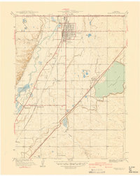 1940 Brighton1940 Print · USGSThe irrigated farmlands of Adams County come to life in this pre-war survey of the South Platte Valley. Genealogists and local historians can trace the footprint of the Denver Poor Farm and old rural schools like Pleasant Plains Sch or Cactus Ridge School.
 - 1940 Map of Englewood
 1940 Englewood1940 Print · USGSBefore the postwar boom, South Denver and Englewood were a landscape of grand country clubs and critical water infrastructure. Trace the early boundaries of Lowry Field Military Reservation and historic sites like Sullivan and the University of Denver.
 - 1940 Map of Mount Powell
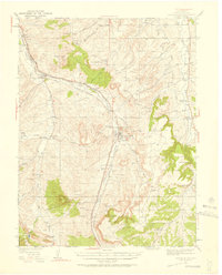
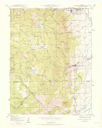
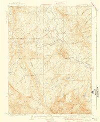 1940 Mount Powell1940 Print · USGSThe high peaks of the Gore Range and the Blue River valley are shown here during the late 1930s. Researchers can locate remote homesteads and schools such as Abbet Place, Smith Ranch, and the Hillcrest Sch among the alpine lakes.3 unique versions available
 - 1940 Map of Piney Creek
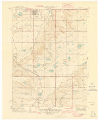
 1940 Piney Creek1940 Print · USGSThe High Plains of the late Depression era come to life here as the tri-county borders of Arapahoe, Douglas, and Elbert converge. Researchers can trace the rugged drainage patterns of Piney Creek, Sulphur Gulch, and Coal Creek before the landscape was altered by modern development.
 - 1940 Map of Savery
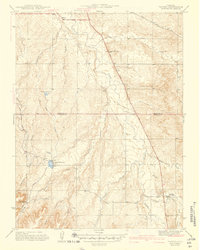
 1940 Savery1940 Print · USGSThe high country of the Wyoming-Colorado border is captured here as the ranching and forest service outposts of the early twentieth century were becoming established. Researchers can trace the remote Snake River drainage and find historic sites like Tullis, Savery, and the Rambler Ranger Sta.2 unique versions available
 - 1940 Map of Eastlake
 1940 Eastlake1940 Print · USGSAdams County at the end of the 1930s shows a landscape of rail-side settlements and intensive irrigation. Genealogists can locate family landmarks like Wesley Chapel, rural school sites such as Moreland Sch, and the water networks of the Brantner Ditch.
 - 1940 Map of Lafayette
 1940 Lafayette1940 Print · USGSLafayette and the northern Colorado coalfields are captured in the late 1930s as mining and rail transport shaped the local economy. Genealogists can trace family roots through named landmarks like Mandalay Sch, Lakeview Cem, and the Centennial Mine.
 - 1940 Map of Derby
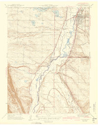
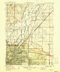 1940 Derby1940 Print · USGSAdams County and north Denver appear here on the eve of World War II, showing a landscape of irrigation ditches, heavy rail, and early aviation. Researchers can trace the legacy of the Stockyards, the sprawling Denver City and Co Airport, and vanished local schools like Mapleton Sch.2 unique versions available
 - 1940 Map of Garfield, 1954 Print
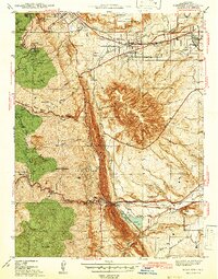
 1940 Garfield1954 Print · USGSThe high Sawatch Range is seen here at the peak of its industrial mining era, straddling the Continental Divide. Genealogists and historians can trace defunct mountain rail routes and remote settlements like St Elmo, Hancock, and the historic Old Alpine Tunnel.6 unique versions available
 - 1940 Map of Elbert, 1956 Print
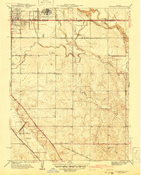
 1940 Elbert1956 Print · USGSThe high plains of Elbert and El Paso counties are captured here in the years leading up to the mid-century, where the edge of the Black Forest meets a network of family ranches. Researchers can trace dozens of country landmarks, from the Chicago Rock Island & Pacific railroad to schoolhouses like James Sch and Sidney Sch.2 unique versions available
 - 1940 Map of Castle Rock, 1958 Print
 1940 Castle Rock1958 Print · USGSDouglas County ranching and rail life are captured here just before the mid-century, centered on the growing crossroads of Castle Rock. Genealogists can locate family-named landmarks and rural schools like Fonder Sch or trace the Bear Canyon Cem near Sedalia.3 unique versions available
 - 1941 Map of Long Branch
 1941 Long Branch1941 Print · USGSThe high plains of Adams County were undergoing a period of vital irrigation and military growth just before the mid-century. Researchers can trace the early layout of Aurora, the massive Fitzsimons General Hospital campus, and the rural rail stops at Sable and Irondale.
 - 1941 Map of Fitzsimons
 1941 Fitzsimons1941 Print · USGSArapahoe County was a landscape of military expansion and rural education just before the war. Trace the early boundaries of the Fitzsimons General Hospital and find local landmarks like Pleasant View Sch and the High Line Canal.2 unique versions available
 - 1941 Map of Arvada
 1941 Arvada1941 Print · USGSThe Arvada and Westminster areas of the Colorado Front Range appear here in the early 1940s, showing a landscape defined by irrigation and rail. Researchers can trace historic institutions like Bellevue College, early settlements at Utah Junction, and the Leyden Narrow Gage railroad.
 - 1941 Map of Fort Logan
 1941 Fort Logan1941 Print · USGSThe western edges of Denver and the community of Sheridan are captured here just before the mid-century population boom. Researchers can trace the layout of the Fort Logan Military Reservation and locate local landmarks like Loretto Heights College and Sloan Lake.
 - 1941 Map of Pitkin, 1954 Print
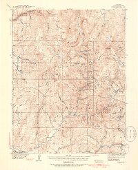 1941 Pitkin1954 Print · USGSGunnison County peaks and high-country mining camps are documented here in the mid-twentieth century. Genealogists and historians can trace families and claims through the Pitkin and Ohio City settlements or locate sites like the Sparta Sch and Gold Links Mine.5 unique versions available
 - 1942 Map of Eldorado Springs
 1942 Eldorado Springs1942 Print · USGSJust before the mid-century, the mountain interface west of Boulder was a landscape of remote ranches and rugged rail lines. Trace the early settlement of Eldorado Springs and find vanished landmarks like the Pine Grove Sch and the Coal Creek Store.4 unique versions available
 - 1942 Map of Highland Ranch
 1942 Highland Ranch1942 Print · USGSThe northern Douglas County ranchlands appear here in the early 1940s as a quiet expanse of large family estates and critical water canals. Researchers can trace the early boundaries of Highland Ranch, locate the Cheese Ranch, and find rural landmarks like Curtis Sch and the Englewood Dam.
 - 1942 Map of Mile High Lakes
 1942 Mile High Lakes1942 Print · USGSAdams County ranching and water engineering are on full display in the early 1940s, as a network of canals transformed the High Plains. Genealogists and local historians can trace legacy holdings like Patton Ranch and Miliken Ranch or locate the vital Klink Siding along the railroad.
 - 1942 Map of Box Elder School
 1942 Box Elder School1942 Print · USGSAdams County ranching and irrigation systems are in full view just before the mid-century, as the city of Denver begins to expand eastward. Trace the early rural school districts at Box Elder Sch and First Creek Sch or follow the path of the Highline Canal.
 - 1942 Map of Morrison
 1942 Morrison1942 Print · USGSThe Jefferson County foothills meet the plains during the early 1940s, revealing a landscape of military camps, schools, and landmark parks. Researchers can trace the development of Golden, locate the Pleasant View Ch, and see the early layout of Red Rocks Park.2 unique versions available
 - 1942 Map of Colorado Springs
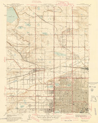
 1942 Colorado Springs1942 Print · USGSColorado Springs and the Front Range appear here in the early years of the Second World War. Genealogists and historians can trace the rail corridors of the Chicago Rock Island and Pacific RR and locate sites like the Printers Home and Glen Eyrie.
 - 1942 Map of Parker
 1942 Parker1942 Print · USGSSoutheast of Denver in the late thirties and early forties, this landscape shows the rural agricultural roots and water management systems of Douglas County. Genealogists can locate family-named landmarks and community centers like Parker, Melvin, and the Happy Canyon Sch.
 - 1942 Map of Golden
 1942 Golden1942 Print · USGSJefferson County before the post-war suburban boom reveals a landscape of industrial transit and coordinated irrigation. Researchers can trace the path of the Denver and Intermountain (Electric) line or locate rural community hubs like Ralston Ch and Fairmount Sch.
 - 1942 Map of Littleton
 1942 Littleton1942 Print · USGSLittleton and the South Platte River valley appear here just before the mid-century boom, shaped by a vital network of railroads and reservoirs. Researchers can trace early rural life at Deer Creek Sch, the riverside siding at Struby, and the waters of Marston Lake.2 unique versions available
Showing maps 1-25 of 130
Top cities of Colorado
- Denver historical maps
- Colorado Springs historical maps
- Aurora historical maps
- Fort Collins historical maps
- Lakewood historical maps
- Thornton historical maps
See more
Top counties of Colorado
- Denver historical maps
- El Paso County historical maps
- Arapahoe County historical maps
- Jefferson County historical maps
- Adams County historical maps
- Larimer County historical maps
See more
Frequently asked questions
- What are the different types of historical maps available for Colorado?
- What is the oldest map of Colorado?
- Where can I purchase historical maps of Colorado for my home or office?
- Where can I download high-res historical maps of Colorado?
- Are there historical topographic maps available for Colorado?
- Is there historical aerial imagery available for Colorado?
- Where are historical maps of Colorado sourced from?