1900s (20th Century) Maps of Chicago, Illinois
Explore 70 historic maps of Chicago from the 1900s (20th Century). These maps offer a rare glimpse into what life looked like during the 1900s — showing old roads, neighborhoods, homes, and landmarks that have changed or disappeared over time.
Whether you're researching your family's past, planning a metal detecting trip, or studying how Chicago's landscape evolved across the 1900s, these high-resolution maps are a powerful tool for exploring the history of this region.
- Focus on a specific era: All maps on this page are from the 1900s, giving you a focused view of this time period.
- See what’s changed: Compare century-old streets, trails, and buildings to today's modern landscape using overlays and satellite layers.
- Research with precision: Use these maps for genealogy, historical research, land use analysis, or educational projects.
- View, download, or print: Maps are fully viewable online in high resolution, and can be downloaded or printed for your own records.
Start exploring Chicago's history through authentic maps from the 1900s. This is your window into the past.
Chicago, IL maps
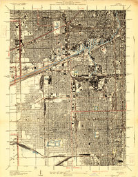
(70)- 1900 Map of Chicago
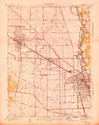
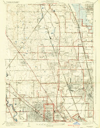
 1900 Chicago1900 Print · USGSChicago at the turn of the century shows a city of massive infrastructure, from its emerging park system to its complex rail hubs. Researchers can trace the development of early neighborhoods like Mayfair and South Lynn or locate grounds like Rose Hill Cemetery and the historic Illinois and Michigan Canal.
 - 1900 Map of Riverside
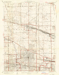
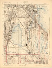
 1900 Riverside1900 Print · USGSThe western Chicago suburbs and the Desplaines River valley are captured here during a period of massive industrial and rail expansion. Genealogists can locate early settlements like Fullersburg and Lace, or trace family plots in Waldheim Cemetery.
 - 1900 Map of Highwood
 1900 Highwood1900 Print · USGSCoastal bluffs and river valleys north of Chicago come alive in this late nineteenth-century survey. Trace the early footprints of settlements like Highland Park and Arlington Heights or locate the historic military grounds at Fort Sheridan.5 unique versions available
 - 1900 Map of Calumet
 1900 Calumet1900 Print · USGSSouthern Cook County and the Indiana borderlands are captured here at the peak of the rail era, showing a landscape of burgeoning industrial towns and complex rail junctions. Researchers can trace the layout of the historic company town of Pullman, the growth of Hammond, and the early footprints of Blue Island and Harvey.
 - 1901 Map of Calumet
 1901 Calumet1901 Print · USGSSouthern Chicago and the Calumet region are captured at the peak of their industrial expansion at the turn of the century. Genealogists and historians can trace the growth of rail-side towns like Pullman, Blue Island, and Hegewisch and locate landmarks like the Glenwood Industrial School.5 unique versions available
 - 1901 Map of Riverside
 1901 Riverside1901 Print · USGSGreater Chicago and the Desplaines River valley are captured here at a moment of rapid rail expansion and civic engineering. Genealogists and historians can trace early settlements and burial sites like Waldheim Cemetery, the Chicago Union Transfer Railroad Yards, and Jefferson Park.4 unique versions available
 - 1901 Map of Chicago
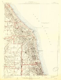
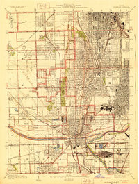
 1901 Chicago1901 Print · USGSChicago was a booming industrial and rail hub in the late nineteenth century, defined by its lakefront and canal systems. Genealogists and urban historians can trace early neighborhood boundaries and rail corridors through Elsdon, Chicago Lawn, and Rose Hill Cemetery.5 unique versions available
 - 1927 Map of Arlington Heights
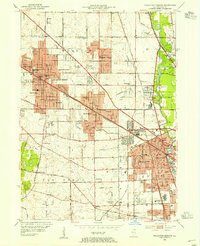
 1927 Arlington Heights1927 Print · USGSCook County in the mid-1920s shows a landscape of emerging rail suburbs and quiet prairie farmland. Genealogists and local historians can trace family-named sites and vanished landmarks like the English Cemetery, Schnells Corner, and St Johns Church.3 unique versions available
 - 1928 Map of Elmhurst
 1928 Elmhurst1928 Print · USGSWestern suburbs like Elmhurst and Bensenville appear in the late 1920s as thriving rail hubs before the postwar housing boom. Researchers can trace early family sites at Friedens Cemetery, locate the Lutheran Orphanage, and see the original layout of Elmhurst College.3 unique versions available
 - 1928 Map of Berwyn
 1928 Berwyn1928 Print · USGSThe suburban expansion west of Chicago is in full swing in the late twenties as industrial and rail networks reshape the land. Trace family history at Waldheim Cemetery or explore early aviation at the Maywood U S Mail Airport.3 unique versions available
 - 1928 Map of Evanston
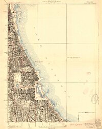
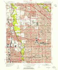
 1928 Evanston1928 Print · USGSThe North Shore suburbs and the northern edge of Chicago are seen in detail during the late 1920s. Local researchers can trace early residential growth near Northwestern University and locate landmarks like the Gross Pt L H or Calvary Cemetery.5 unique versions available
 - 1928 Map of River Forest
 1928 River Forest1928 Print · USGSIn the late twenties, the Chicago city limits pushed westward toward the Des Plaines River, transforming prairie and farmland into a dense suburban grid. Genealogists and historians can trace family plots in St Joseph Cemetery or locate early landmarks like Rosary College and the Chicago State Hospital.4 unique versions available
 - 1929 Map of Park Ridge
 1929 Park Ridge1929 Print · USGSNorth of Chicago in the late twenties, this area was rapidly evolving from agricultural land into a network of suburban settlements. Genealogists and historians can trace institutional sites like the St Marys Mission House and early cemeteries such as Maine Cemetery or Sunset Cemetery.3 unique versions available
 - 1929 Map of Calumet Lake
 1929 Calumet Lake1929 Print · USGSThe industrial heart of the South Side and the Indiana borderlands comes alive in this survey of the Calumet region. Genealogists and historians can trace the streets of Pullman, the extensive rail yards of the Belt Ry of Chicago, and early features like the Pullman Training School.3 unique versions available
 - 1929 Map of Blue Island
 1929 Blue Island1929 Print · USGSSouth Chicago and its suburbs are captured in the late twenties during a period of rapid industrial and rail expansion. Genealogists can trace family plots across Mt Hope and Oak Hill, or locate local landmarks like Bremen School and Blue Island.3 unique versions available
 - 1929 Map of Jackson Park
 1929 Jackson Park1929 Print · USGSThe South Side of Chicago during the late 1920s reveals a sophisticated network of grand parks and lakefront landmarks. Genealogists and urban historians can trace the grid from Oakwoods Cemetery to iconic sites like Soldiers Field and the Field Museum.3 unique versions available
 - 1929 Map of Englewood
 1929 Englewood1929 Print · USGSThe South Side of Chicago in the mid-twenties shows a landscape transformed by heavy industry and rail transport. Genealogy and local history researchers can trace the dense grid around the Union Stock Yards, Englewood, and the sprawling Corwith Yards.3 unique versions available
 - 1929 Map of Chicago Loop, 1939 Print
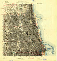 1929 Chicago Loop1939 Print · USGSChicago and its lakefront are captured here between the world wars, showing a city defined by its rigid grid and grand public parks. Genealogists and historians can trace old neighborhoods near Rose Hill Cemetery, the grounds of Loyola University, or the original layout of the Municipal Pier.2 unique versions available
 - 1953 Map of Arlington Heights, 1955 Print
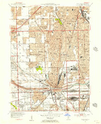
 1953 Arlington Heights1955 Print · USGSPost-war Cook County comes alive in this survey of the growing corridor from Arlington Heights to Des Plaines. Trace family roots at All Saints Cem or locate the early footprints of Pal-Waukee Airport and O'Hare Field.
 - 1953 Map of Calumet Lake, 1955 Print
 1953 Calumet Lake1955 Print · USGSThe industrial corridor of the Chicago South Side and Northwest Indiana comes alive in this mid-century survey. Genealogists and historians can trace the footprint of neighborhoods like Pullman, Hegewisch, and Altgeld Gardens alongside the massive rail yards of the Pennsylvania Railroad.
 - 1953 Map of River Forest, 1955 Print
 1953 River Forest1955 Print · USGSSuburban Cook County is seen in a period of dense growth during the early fifties, showing the maturing street grids of River Grove and Oak Park. Genealogists can locate numerous local landmarks like St Joseph Cemetery and schools such as Wright Jr College.
 - 1953 Map of Evanston, 1955 Print
 1953 Evanston1955 Print · USGSThe North Shore suburbs and northern Chicago lakefront are captured in the mid-1950s as these rail-connected communities reached their peak maturity. Researchers can trace historic campus footprints at Northwestern University or locate family sites near Calvary Cemetery and New Trier High Sch.
 - 1953 Map of Chicago Loop, 1956 Print
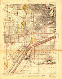
 1953 Chicago Loop1956 Print · USGSMid-century Chicago is captured here at a moment of significant infrastructure expansion and urban density. Genealogists and historians can trace neighborhood parish schools like St Michael High Sch, local cemeteries such as Rosehill Cemetery, and the rise of the Congress Street Expressway.
 - 1953 Map of Blue Island, 1956 Print
 1953 Blue Island1956 Print · USGSBlue Island and the southern Chicago suburbs are shown here in a period of significant postwar growth and heavy rail industrialization. Genealogists and local historians can trace the vast cemetery lands of Mt Greenwood Cemetery or find defunct landmarks like Howell Airport and the Rock Island RR lines.
 - 1953 Map of Jackson Park, 1956 Print
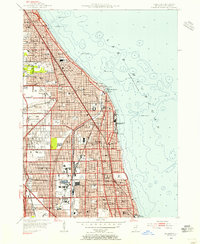
 1953 Jackson Park1956 Print · USGSThe South Side of Chicago and its lakefront are captured here in the early 1950s, showing a period of significant urban growth and shoreline development. Genealogists and historians can trace neighborhood landmarks from Oakwoods Cemetery to the University of Chicago and the aviation grounds of Meigs Field.
Showing maps 1-25 of 70
Top cities near Chicago
- Cicero historical maps
- Hammond historical maps
- Arlington Heights historical maps
- Evanston historical maps
- Skokie historical maps
- Des Plaines historical maps
See more
Top neighborhoods of Chicago
- West Chicago Township historical maps
- Lake View Township historical maps
- Rogers Park Township historical maps
- Jefferson Township historical maps
- Lake Township historical maps
- Hyde Park Township historical maps
See more
Frequently asked questions
- What are the different types of historical maps available for Chicago?
- What is the oldest map of Chicago?
- Where can I purchase historical maps of Chicago for my home or office?
- Where can I download high-res historical maps of Chicago?
- Are there historical topographic maps available for Chicago?
- Is there historical aerial imagery available for Chicago?
- Where are historical maps of Chicago sourced from?