
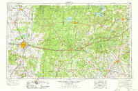
1954 Map of Abilene
USGS Topo · Published 1966About this map
Abilene and its surrounding central Texas plains are depicted here during a period of significant water infrastructure expansion and petroleum activity. The map showcases a landscape defined by its transition from frontier ranching to a modern industrial and military hub, particularly visible near the Fort Phantom Hill Ruins and the extensive network of oil and gas fields peppered across the ranchlands. The development of major reservoirs like Hubbard Creek Lake, Leon Reservoir, and Possum Kingdom Lake illustrates the region's mid-century effort to manage the water resources of the Clear Fork Brazos River and Sabana River.
Find a feature on this map
143 named features on this map. Tap any name to fly to it.
Don’t see what you’re looking for? This feature index may not catch every label — zoom into the map to look around manually.
Map Details
Editions of this 1954 Abilene Map
2 editions found
Other maps of this area

1887 · Coleman
USGS Topo · 1:125,000

1888 · Hamilton
USGS Topo · 1:125,000

1888 · Meridian
USGS Topo · 1:125,000

1889 · Granbury
USGS Topo · 1:125,000

1889 · Brownwood
USGS Topo · 1:125,000

1889 · Coleman
USGS Topo · 1:125,000

1890 · Stephenville
USGS Topo · 1:125,000

1890 · Breckenridge
USGS Topo · 1:125,000

1890 · Abilene
USGS Topo · 1:125,000

1891 · Weatherford
USGS Topo · 1:125,000