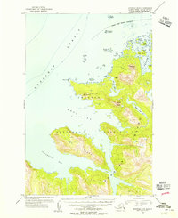
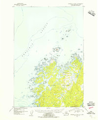
1954 Map of Afognak B-3
USGS Topo · Published 1955About this map
Afognak Island and the neighboring Chugach Islands are depicted here during a mid-century period of federal mapping in the Alaska Territory. The landscape is dominated by the steep elevations of Devilpaw Mountain and Dome Peak, which rise sharply from the convoluted shoreline of the Shelikof Strait. Human presence is minimal, evidenced only by a single Cabin located near Devil Inlet, suggesting a period of seasonal hunting or surveying rather than permanent settlement.
Find a feature on this map
25 named features on this map. Tap any name to fly to it.
Don’t see what you’re looking for? This feature index may not catch every label — zoom into the map to look around manually.
Map Details
Editions of this 1954 Afognak B-3 Map
3 editions found
Other maps of this area

1952 · Afognak
USGS Topo · 1:250,000

1952 · Afognak A-4
USGS Topo · 1:63,360

1952 · Afognak A-3
USGS Topo · 1:63,360

1952 · Afognak A-2
USGS Topo · 1:63,360
1952 · Afognak C-2 and C-3
USGS Topo · 1:63,360

1952 · Afognak B-2
USGS Topo · 1:63,360
1952 · Afognak B-4
USGS Topo · 1:63,360

1953 · Afognak A-4
USGS Topo · 1:63,360

1954 · Afognak B-3
USGS Topo · 1:63,360
1954 · Afognak C-2 and C-3
USGS Topo · 1:63,360