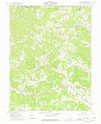
1961 Map of Allensville
USGS Topo · Published 1977About this map
Wayne National Forest land dominates this rugged Vinton County landscape, where deep hollows like Bray Hollow and high ridges such as Locust Grove Ridge define the topography. The map illustrates a rural area characterized by small church-centered communities and family cemeteries scattered along the winding drainages of Salt Creek and Middle Fork. In the southern portion of the quadrangle, the village of Allensville serves as a local hub near Riley Run, while further north, the community of Royal is situated along the forest boundary. Cultural landmarks include several country chapels, such as Walnut Grove Ch and Otterbein Chapel, alongside a notable Covered Bridge on the Salt Creek tributary. The terrain is marked by extractive industries, with numerous Gas Wells and active Strip Mines appearing throughout the forest and private land holdings, particularly in the vicinity of Elk Ridge.
Find a feature on this map
39 named features on this map. Tap any name to fly to it.
Don’t see what you’re looking for? This feature index may not catch every label — zoom into the map to look around manually.
Map Details
Editions of this 1961 Allensville Map
4 editions found
Other maps of this area

1904 · Zaleski
USGS Topo · 1:62,500

1905 · Wilkesville
USGS Topo · 1:62,500

1907 · Zaleski
USGS Topo · 1:62,500

1908 · Wilkesville
USGS Topo · 1:62,500

1910 · Laurelville
USGS Topo · 1:62,500

1912 · Laurelville
USGS Topo · 1:62,500

1913 · Jackson
USGS Topo · 1:62,500

1944 · Jackson
USGS Topo · 1:62,500

1944 · Laurelville
USGS Topo · 1:62,500

1947 · Columbus
USGS Topo · 1:250,000