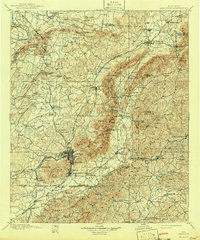
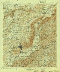
1900 Map of Anniston
USGS Topo · Published 1942About this map
Anniston serves as the industrial and transit hub in this late 19th-century survey, where the Southern Railway and the Louisville and Nashville RR converge. The landscape is defined by the sharp ridges of Colvin Mt. and Oak Mt., which dictate the placement of smaller agricultural settlements like Alexandria and Grayton. Moving away from the rail corridors, the map reveals a decentralized economy of water-powered industry, with Whitesides Mill on Shoal Creek and Beasons Mill on Mud Creek serving local farmers. To the west, the Coosa River remains a primary boundary and thoroughfare, anchored by crossings such as Fowler Ferry. This survey documents a transitional era for Calhoun and Cleburne counties, showing established centers like Oxanna and Oxford alongside rural landmarks like the Salt Creek Church and the rugged passes of Rattlesnake Mountain.
Find a feature on this map
141 named features on this map. Tap any name to fly to it.
Don’t see what you’re looking for? This feature index may not catch every label — zoom into the map to look around manually.
Map Details
Editions of this 1900 Anniston Map
6 editions found

Other maps of this area

1885 · Gadsden
USGS Topo · 1:125,000

1886 · Rome
USGS Topo · 1:125,000

1888 · Gadsden
USGS Topo · 1:125,000

1889 · Tallapoosa
USGS Topo · 1:125,000

1889 · Springville
USGS Topo · 1:125,000

1890 · Talladega
USGS Topo · 1:125,000

1891 · Ashland
USGS Topo · 1:125,000

1892 · Springville
USGS Topo · 1:125,000

1892 · Talladega
USGS Topo · 1:125,000

1892 · Tallapoosa
USGS Topo · 1:125,000