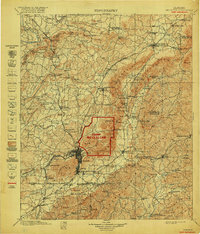
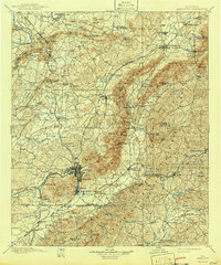
1900 Map of Anniston
USGS Topo · Published 1918About this map
Camp Mc Clellan stands as the central focal point of this survey, overprinted in red to reflect its strategic importance during the era of military expansion following the turn of the century. The surrounding landscape of Anniston and Jacksonville is defined by the heavy presence of the Southern Railway and the Louisville and Nashville RR, which facilitated the regional iron and timber economies. Along the winding Choccolocco Creek, small industrial and agrarian nodes like Whitesides Mill and Beasons Mill appear alongside family-named landmarks such as Mokeley Hill and Ben White Point. To the east, the map details early river crossings like Evans Bridge over the Tallapoosa River and the settlement of Arbacochee, providing a detailed view of eastern Alabama's transition from rural gold-mining districts to a more structured industrial and military corridor.
Find a feature on this map
144 named features on this map. Tap any name to fly to it.
Don’t see what you’re looking for? This feature index may not catch every label — zoom into the map to look around manually.
Map Details
Editions of this 1900 Anniston Map
6 editions found

Other maps of this area

1885 · Gadsden
USGS Topo · 1:125,000

1886 · Rome
USGS Topo · 1:125,000

1888 · Gadsden
USGS Topo · 1:125,000

1889 · Tallapoosa
USGS Topo · 1:125,000

1889 · Springville
USGS Topo · 1:125,000

1890 · Talladega
USGS Topo · 1:125,000

1891 · Ashland
USGS Topo · 1:125,000

1892 · Springville
USGS Topo · 1:125,000

1892 · Talladega
USGS Topo · 1:125,000

1892 · Tallapoosa
USGS Topo · 1:125,000