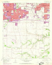
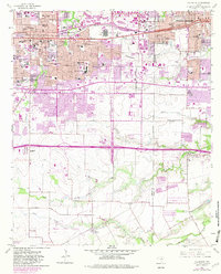
1959 Map of Arlington
USGS Topo · Published 1969About this map
The growing metropolitan corridor between Arlington and Grand Prairie reveals a mid-century landscape in rapid transition. Industrial and academic anchors like the Automobile Assembly Plant and Arlington State College define the northern urbanized zones, while the southern reaches remain relatively open with family-named roads like Poly-Webb Road and Duncanville Florence Hill Road. The 1968 revisions (highlighted in purple) track the expansion of residential subdivisions and suburban infrastructure over a decade of significant growth.
Find a feature on this map
66 named features on this map. Tap any name to fly to it.
Don’t see what you’re looking for? This feature index may not catch every label — zoom into the map to look around manually.
Map Details
Editions of this 1959 Arlington Map
6 editions found
Other maps of this area

1891 · Dallas
USGS Topo · 1:125,000

1893 · Dallas
USGS Topo · 1:125,000

1894 · Fort Worth
USGS Topo · 1:125,000

1931 · Carrollton
USGS Topo · 1:62,500

1931 · Grapevine
USGS Topo · 1:62,500

1954 · Dallas
USGS Topo · 1:250,000

1958 · Dallas
USGS Topo · 1:250,000

1959 · Kennedale
USGS Topo · 1:24,000

1959 · Arlington
USGS Topo · 1:24,000

1959 · Euless
USGS Topo · 1:24,000
Featured Places
- Arlington, TX
- Grand Prairie, TX
- Lakewood, Grand Prairie
- Ameserio Estates, Grand Prairie
- Westchester, Grand Prairie