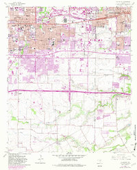
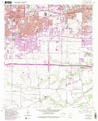
1959 Map of Arlington
USGS Topo · Published 1982About this map
Arlington and Grand Prairie appear at a critical juncture of post-war expansion, with the Missouri Pacific railroad corridor anchoring the older industrial and residential core. The landscape reflects the transition from rural agricultural land to a suburban educational and transit hub, anchored by the presence of Arlington State College. Significant infrastructure like the Arlington Municipal Airport and Grand Prairie Municipal Airport indicates the region's mid-century orientation toward aviation and defense-related growth.
Find a feature on this map
73 named features on this map. Tap any name to fly to it.
Don’t see what you’re looking for? This feature index may not catch every label — zoom into the map to look around manually.
Map Details
Editions of this 1959 Arlington Map
6 editions found
Other maps of this area

1891 · Dallas
USGS Topo · 1:125,000

1893 · Dallas
USGS Topo · 1:125,000

1894 · Fort Worth
USGS Topo · 1:125,000

1931 · Carrollton
USGS Topo · 1:62,500

1931 · Grapevine
USGS Topo · 1:62,500

1954 · Dallas
USGS Topo · 1:250,000

1958 · Dallas
USGS Topo · 1:250,000

1959 · Kennedale
USGS Topo · 1:24,000

1959 · Arlington
USGS Topo · 1:24,000

1959 · Euless
USGS Topo · 1:24,000
Featured Places
- Arlington, TX
- Grand Prairie, TX
- Lakewood, Grand Prairie
- Ameserio Estates, Grand Prairie
- Westchester, Grand Prairie