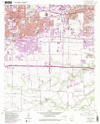
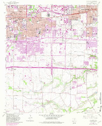
1959 Map of Arlington
USGS Topo · Published 1982About this map
The rapid post-war expansion of the Mid-Cities is etched into this document, showing Arlington and Grand Prairie as they transitioned from suburban towns to a sprawling industrial and educational corridor. The campus of Arlington State College stands as a central anchor, surrounded by established neighborhoods and burgeoning developments like Southland Acres. The landscape is defined by the Missouri Pacific rail line and the newly completed Interstate 30, which fueled the regional growth. Aviation plays a significant role in the local economy, evidenced by both the Grand Prairie Municipal Airport and the Arlington Municipal Airport. Numerous local landmarks are preserved here, from the St Maria Goretti Sch to the Southland Memorial Park (Cemetery), while the creek beds of Johnson Creek and Fish Creek provide a natural contrast to the increasing urbanization of Tarrant and Dallas counties.
Find a feature on this map
68 named features on this map. Tap any name to fly to it.
Don’t see what you’re looking for? This feature index may not catch every label — zoom into the map to look around manually.
Map Details
Editions of this 1959 Arlington Map
6 editions found
Other maps of this area

1891 · Dallas
USGS Topo · 1:125,000

1893 · Dallas
USGS Topo · 1:125,000

1894 · Fort Worth
USGS Topo · 1:125,000

1931 · Carrollton
USGS Topo · 1:62,500

1931 · Grapevine
USGS Topo · 1:62,500

1954 · Dallas
USGS Topo · 1:250,000

1958 · Dallas
USGS Topo · 1:250,000

1959 · Kennedale
USGS Topo · 1:24,000

1959 · Arlington
USGS Topo · 1:24,000

1959 · Euless
USGS Topo · 1:24,000
Featured Places
- Arlington, TX
- Grand Prairie, TX
- Lakewood, Grand Prairie
- Ameserio Estates, Grand Prairie
- Westchester, Grand Prairie