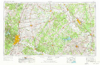
1954 Map of Austin
USGS Topo · Published 1976About this map
Austin and its burgeoning mid-century corridor serve as the anchor for this regional survey, capturing the Texas capital before the massive expansion of the modern era. The landscape is defined by the winding course of the Colorado River and the Brazos River, with the University of Texas and the State Capitol marking the urban core. To the east, the institutional presence of Texas A & M University in College Station and Prairie View A & M College highlights the importance of higher education in the Brazos Valley's development.
Find a feature on this map
201 named features on this map. Tap any name to fly to it.
Don’t see what you’re looking for? This feature index may not catch every label — zoom into the map to look around manually.
Map Details
Editions of this 1954 Austin Map
4 editions found

Other maps of this area

1885 · Taylor
USGS Topo · 1:125,000

1885 · Bastrop
USGS Topo · 1:125,000

1887 · Taylor
USGS Topo · 1:125,000

1887 · Lampasas
USGS Topo · 1:125,000

1887 · Blanco
USGS Topo · 1:125,000

1887 · Burnet
USGS Topo · 1:125,000

1892 · Temple
USGS Topo · 1:125,000

1893 · Georgetown
USGS Topo · 1:125,000

1893 · Burnet
USGS Topo · 1:125,000

1893 · Bastrop
USGS Topo · 1:125,000