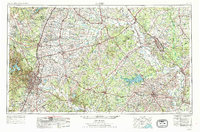
1954 Map of Austin
USGS Topo · Published 1988About this map
The Brazos River and Colorado River systems anchor this mid-century look at Central Texas, showing the region as it transitioned into the modern era. The state capital, Austin, is depicted alongside emerging suburbs like Pflugerville and Jollyville Plateau, while the eastern reaches highlight the academic hubs of Bryan and College Station. The map illustrates a landscape of varied utility, featuring an Aluminum Plant and oil fields alongside recreational spaces such as Lake Somerville and Bastrop St Pk.
Find a feature on this map
130 named features on this map. Tap any name to fly to it.
Don’t see what you’re looking for? This feature index may not catch every label — zoom into the map to look around manually.
Map Details
Editions of this 1954 Austin Map
4 editions found

Other maps of this area

1885 · Taylor
USGS Topo · 1:125,000

1885 · Bastrop
USGS Topo · 1:125,000

1887 · Taylor
USGS Topo · 1:125,000

1887 · Lampasas
USGS Topo · 1:125,000

1887 · Blanco
USGS Topo · 1:125,000

1887 · Burnet
USGS Topo · 1:125,000

1892 · Temple
USGS Topo · 1:125,000

1893 · Georgetown
USGS Topo · 1:125,000

1893 · Burnet
USGS Topo · 1:125,000

1893 · Bastrop
USGS Topo · 1:125,000