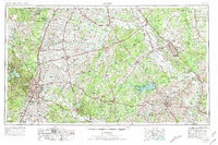
1954 Map of Austin
USGS Topo · Published 1976About this map
Austin and the surrounding Central Texas counties are depicted here during a period of significant mid-century expansion. The transition from the Jollyville Plateau across the Balcones Escarpment creates a striking topographic divide between the western hills and the eastern plains. In the north, Fort Hood occupies a massive footprint near the Lampasas River, while Camp Mabry remains a focal point within the capital city. The regional hydrography is anchored by the Colorado River and the newly formed Lake Somerville, which had only recently altered the landscape of the Yegua Creek basin.
Find a feature on this map
305 named features on this map. Tap any name to fly to it.
Don’t see what you’re looking for? This feature index may not catch every label — zoom into the map to look around manually.
Map Details
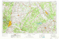
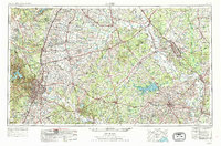
Editions of this 1954 Austin Map
4 editions found

Other maps of this area

1885 · Taylor
USGS Topo · 1:125,000

1885 · Bastrop
USGS Topo · 1:125,000

1887 · Taylor
USGS Topo · 1:125,000

1887 · Lampasas
USGS Topo · 1:125,000
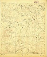
1887 · Blanco
USGS Topo · 1:125,000

1887 · Burnet
USGS Topo · 1:125,000

1892 · Temple
USGS Topo · 1:125,000

1893 · Georgetown
USGS Topo · 1:125,000

1893 · Burnet
USGS Topo · 1:125,000

1893 · Bastrop
USGS Topo · 1:125,000