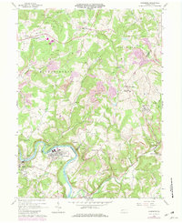
1964 Map of Avonmore
USGS Topo · Published 1982About this map
The Kiskiminetas River carves a deep valley through the Western Pennsylvania landscape, serving as a natural boundary between Westmoreland, Armstrong, and Indiana Counties. In the early 1960s, the borough of Avonmore functioned as a river-bound hub for the Conrail line, surrounded by a complex industrial network of extractive resource sites. Extensive Strip Mines are mapped throughout the eastern hills, particularly near Elders Ridge and Maysville, illustrating the era's reliance on surface coal mining. Local life is documented through numerous rural institutions, from the Clarksburg Ch and Union Cem to educational landmarks like the Elders Ridge Joint High Sch. Dozens of Gas Wells and several Pipelines crisscross the terrain, marking the subsurface energy economy that defined this region alongside the larger settlements of Spring Church and Salina.
Find a feature on this map
50 named features on this map. Tap any name to fly to it.
Don’t see what you’re looking for? This feature index may not catch every label — zoom into the map to look around manually.
Map Details
Editions of this 1964 Avonmore Map
4 editions found
Other maps of this area

1900 · Latrobe
USGS Topo · 1:62,500

1902 · Latrobe
USGS Topo · 1:62,500

1902 · Elders Ridge
USGS Topo · 1:62,500

1903 · Latrobe
USGS Topo · 1:62,500

1904 · Elders Ridge
USGS Topo · 1:62,500

1904 · Greensburg
USGS Topo · 1:62,500

1906 · Greensburg
USGS Topo · 1:62,500

1907 · Freeport
USGS Topo · 1:62,500

1909 · Freeport
USGS Topo · 1:62,500

1953 · Pittsburgh
USGS Topo · 1:250,000