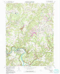
1964 Map of Avonmore
USGS Topo · Published 1993About this map
Kiskiminetas River and Conemaugh River converge in this western Pennsylvania landscape, defining a region of steep valleys and industrial heritage. The map documents a period when coal mining and rail transport were central to the local economy, as seen in the numerous strip mines and the Mine Tipple near Salina. Small crossroads settlements like Spring Church, Maysville, and Elders Ridge serve as focal points for rural life, connected by a network of roads that wind through the complex topography.
Find a feature on this map
52 named features on this map. Tap any name to fly to it.
Don’t see what you’re looking for? This feature index may not catch every label — zoom into the map to look around manually.
Map Details
Editions of this 1964 Avonmore Map
4 editions found
Other maps of this area

1900 · Latrobe
USGS Topo · 1:62,500

1902 · Latrobe
USGS Topo · 1:62,500

1902 · Elders Ridge
USGS Topo · 1:62,500

1903 · Latrobe
USGS Topo · 1:62,500

1904 · Elders Ridge
USGS Topo · 1:62,500

1904 · Greensburg
USGS Topo · 1:62,500

1906 · Greensburg
USGS Topo · 1:62,500

1907 · Freeport
USGS Topo · 1:62,500

1909 · Freeport
USGS Topo · 1:62,500

1953 · Pittsburgh
USGS Topo · 1:250,000