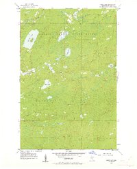
1954 Map of Barrs Lake
USGS Topo · Published 1962About this map
The Cloquet Valley State Forest dominates this section of St. Louis County, where the transition from mid-century forestry to conservation is evident. A notable landmark for local historians is the site of School No 27 (Abandoned) in the northwest, signaling the retreat of early 20th-century rural school districts. The landscape is defined by a dense network of glacial water bodies, including the centrally located Barrs Lake, the large Lieuna Lake, and the uniquely named Esswhtiar Lake.
Find a feature on this map
21 named features on this map. Tap any name to fly to it.
Don’t see what you’re looking for? This feature index may not catch every label — zoom into the map to look around manually.
Map Details
Editions of this 1954 Barrs Lake Map
4 editions found
Other maps of this area

1895 · Duluth
USGS Topo · 1:62,500

1953 · French River
USGS Topo · 1:24,000

1953 · Arnold
USGS Topo · 1:24,000

1953 · Knife River
USGS Topo · 1:24,000

1953 · Duluth
USGS Topo · 1:62,500

1953 · Ashland
USGS Topo · 1:250,000

1953 · Duluth
USGS Topo · 1:250,000

1954 · Barrs Lake
USGS Topo · 1:24,000

1954 · Thompson Lake
USGS Topo · 1:24,000

1954 · Mc Carthy Creek
USGS Topo · 1:24,000