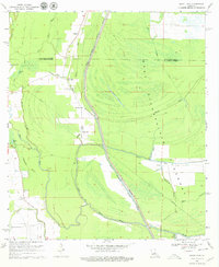
1969 Map of Bayou Jack
USGS Topo · Published 1979About this map
West Atchafalaya Floodway dominates the eastern half of this landscape, reflecting mid-century water management efforts along the West Des Glaises Protection Levee. In the late 1960s, this area of St. Landry and Avoyelles Parishes remained a complex network of waterways, where the Diversion Channel cuts through a dense forest of bayous. Small rural centers like Bayou Jack and Taterville sit west of the floodway, supported by local landmarks such as Bayou Jack School and the Apostolic Church. To the south, the terrain opens into Prairie Rouge, where the Mt Olive Church and Cason Cemetery serve the surrounding community. The map reveals the intricate drainage patterns of the region, from the winding path of Bayou Horsehead to the larger Bayou Rouge, illustrating how natural hydrology and human-made levees defined local settlement.
Find a feature on this map
35 named features on this map. Tap any name to fly to it.
Don’t see what you’re looking for? This feature index may not catch every label — zoom into the map to look around manually.
Map Details
Editions of this 1969 Bayou Jack Map
3 editions found
Other maps of this area

1939 · Opelousas
USGS Topo · 1:62,500

1948 · Bunkie
USGS Topo · 1:62,500

1952 · Lake Charles
USGS Topo · 1:250,000

1954 · Lake Charles
USGS Topo · 1:250,000

1954 · Baton Rouge
USGS Topo · 1:250,000

1955 · Odenburg
USGS Topo · 1:62,500

1956 · Opelousas
USGS Topo · 1:62,500

1956 · Baton Rouge
USGS Topo · 1:250,000

1957 · Opelousas
USGS Topo · 1:62,500

1959 · Palmetto
USGS Topo · 1:62,500