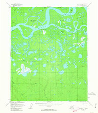
1956 Map of Beaver A-3
USGS Topo · Published 1963About this map
The Yukon River carves a complex network of braids and bypasses through the interior Alaska landscape on this 1950s survey. The dynamic nature of the river system is evident in the numerous features like Kings Slough and Marten Slough, which frame the large Kings Slough Island. A notable human mark on the landscape is Kings Slough Village (Aband), indicating a settled site that had already been vacated by the time of the mid-century field annotation. The terrain is a mixture of active waterways and stagnant features like Raspberry Lake and Herman Lake.
Find a feature on this map
23 named features on this map. Tap any name to fly to it.
Don’t see what you’re looking for? This feature index may not catch every label — zoom into the map to look around manually.
Map Details
Editions of this 1956 Beaver A-3 Map
3 editions found

Other maps of this area

1945 · Livengood
USGS Topo · 1:250,000

1951 · Livengood
USGS Topo · 1:250,000

1951 · Beaver
USGS Topo · 1:250,000

1951 · Livengood D-3
USGS Topo · 1:63,360

1952 · Livengood D-2
USGS Topo · 1:63,360

1953 · Livengood D-4
USGS Topo · 1:63,360

1954 · Livengood D-4
USGS Topo · 1:63,360
1954 · Livengood D-2
USGS Topo · 1:63,360
1954 · Livengood D-3
USGS Topo · 1:63,360

1956 · Beaver B-2
USGS Topo · 1:63,360