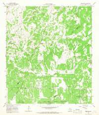
1964 Map of Bergheim
USGS Topo · Published 1967About this map
Bergheim serves as a central point of settlement in this Hill Country landscape, where the convergence of Kendall and Comal counties meets the northern reaches of the Leon Springs Military Reservation. The terrain is defined by a dense network of seasonal drainages including Honey Creek and Swede Creek, which carve through the limestone topography toward Cibolo Creek. Genealogists will find significant value in the numerous family and community burial grounds documented here, such as Bergheim Cem, Kruckemeyer Cem, and Saur Cem. The mid-1960s era shows a transition toward modern rural development with the appearance of Canyon View Acres and a Landing Strip, even as older land use patterns remain visible through scattered quarries and gravel pits along the creek beds of Pleasant Valley.
Find a feature on this map
34 named features on this map. Tap any name to fly to it.
Don’t see what you’re looking for? This feature index may not catch every label — zoom into the map to look around manually.
Map Details
Editions of this 1964 Bergheim Map
2 editions found
Other maps of this area

1920 · Smithsons Valley
USGS Topo · 1:62,500

1927 · Smithson Valley
USGS Topo · 1:62,500

1929 · Smithson Valley
USGS Topo · 1:62,500

1940 · Smithson Valley
USGS Topo · 1:62,500

1953 · Otis Ridge
USGS Topo · 1:24,000

1953 · Bulverde
USGS Topo · 1:24,000

1953 · Van Raub
USGS Topo · 1:24,000

1954 · San Antonio
USGS Topo · 1:250,000

1957 · Boerne
USGS Topo · 1:62,500

1957 · San Antonio
USGS Topo · 1:250,000