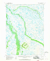
1954 Map of Bethel C-6
USGS Topo · Published 1970About this map
Three Step Mountain rises above a sprawling landscape of wetlands and meandering waterways in this mid-century survey of the Alaska interior. The terrain is defined by the complex drainage systems of the Kwethluk River, which dominates the western portion of the map, and the Akulikutak River, which cuts through the center. To the north, the Kushluk River winds across the tundra, while Columbia Creek appears in the northeast. This 1954 data, compiled through photogrammetric methods from aerial photographs, reveals a wilderness devoid of roads or permanent settlements at the time of mapping. The intricate network of thousands of small lakes and ponds demonstrates the characteristic permafrost-influenced hydrology of the Yukon-Kuskokwim Delta region before modern development or infrastructure reached this remote territory.
Find a feature on this map
5 named features on this map. Tap any name to fly to it.
Don’t see what you’re looking for? This feature index may not catch every label — zoom into the map to look around manually.
Map Details
Editions of this 1954 Bethel C-6 Map
2 editions found
Other maps of this area

1950 · Bethel
USGS Topo · 1:250,000

1954 · Bethel B-6
USGS Topo · 1:63,360

1954 · Bethel C-6
USGS Topo · 1:63,360

1954 · Bethel C-5
USGS Topo · 1:63,360

1954 · Bethel D-7
USGS Topo · 1:63,360

1954 · Bethel B-7
USGS Topo · 1:63,360

1954 · Bethel D-6
USGS Topo · 1:63,360
1954 · Bethel C-7
USGS Topo · 1:63,360

1954 · Bethel D-5
USGS Topo · 1:63,360

1954 · Bethel B-5
USGS Topo · 1:63,360