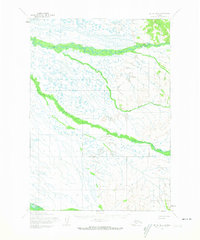
1954 Map of Bethel D-4
USGS Topo · Published 1974About this map
Tuluksak River and Kisaralik River dominate this 1950s landscape in the Bethel region, winding through a complex network of wetlands and tributaries. The map reveals a remote subarctic environment defined by seasonal movement, as evidenced by the Winter Trail and its approximate branches cutting across the northern reaches. These trails underscore the historical reliance on frozen waterways and snow-covered ground for travel in the Kuskokwim River drainage before modern infrastructure. The hydrology is remarkably dense, featuring the meandering paths of Fog River and Otter Creek, which weave between countless unnamed lakes and marshy depressions. This survey captures a moment when land lines were predetermined by the Bureau of Land Management but remained unsurveyed on the ground, reflecting the early administrative efforts to map the Alaskan interior.
Find a feature on this map
6 named features on this map. Tap any name to fly to it.
Don’t see what you’re looking for? This feature index may not catch every label — zoom into the map to look around manually.
Map Details
Editions of this 1954 Bethel D-4 Map
3 editions found
Other maps of this area

1947 · Russian Mission
USGS Topo · 1:250,000

1950 · Russian Mission
USGS Topo · 1:250,000

1950 · Bethel
USGS Topo · 1:250,000

1954 · Russian Mission A-4
USGS Topo · 1:63,360

1954 · Russian Mission A-5
USGS Topo · 1:63,360

1954 · Bethel D-4
USGS Topo · 1:63,360

1954 · Bethel C-5
USGS Topo · 1:63,360

1954 · Bethel C-4
USGS Topo · 1:63,360

1954 · Bethel C-3
USGS Topo · 1:63,360

1954 · Bethel D-5
USGS Topo · 1:63,360