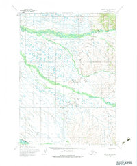
1954 Map of Bethel D-4
USGS Topo · Published 1983About this map
Tuluksak River winds across a landscape defined by seasonal movement and tundra drainage in the mid-1950s. This interior Alaskan terrain is navigated via the Winter Trail, which provides a critical overland route when the ground is frozen. The river systems, including Otter Creek and the Fog River, dominate the topography with complex meanders and numerous small water bodies. In the southern portion of the map, the Kisaralik adds to the network of waterways that shaped local travel and resource access during this era. The map reflects a time of careful photogrammetric survey by the Army Map Service, documenting unsurveyed land lines as predetermined by the Bureau of Land Management before extensive modern development.
Find a feature on this map
6 named features on this map. Tap any name to fly to it.
Don’t see what you’re looking for? This feature index may not catch every label — zoom into the map to look around manually.
Map Details
Editions of this 1954 Bethel D-4 Map
3 editions found
Other maps of this area

1947 · Russian Mission
USGS Topo · 1:250,000

1950 · Russian Mission
USGS Topo · 1:250,000

1950 · Bethel
USGS Topo · 1:250,000

1954 · Russian Mission A-4
USGS Topo · 1:63,360

1954 · Russian Mission A-5
USGS Topo · 1:63,360

1954 · Bethel D-4
USGS Topo · 1:63,360

1954 · Bethel C-5
USGS Topo · 1:63,360

1954 · Bethel C-4
USGS Topo · 1:63,360

1954 · Bethel C-3
USGS Topo · 1:63,360

1954 · Bethel D-5
USGS Topo · 1:63,360