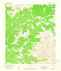
1958 Map of Big Delta D-1
USGS Topo · Published 1967About this map
The Military Reservation dominates the central landscape of this interior Alaskan territory, indicating the mid-century strategic importance of the region near the Fairbanks North Star Borough Bdy. A complex network of waterways defines the terrain, with the Salcha River flowing along the western edge, fed by numerous tributaries such as Serpentine Creek and Lost Creek.
Find a feature on this map
9 named features on this map. Tap any name to fly to it.
Don’t see what you’re looking for? This feature index may not catch every label — zoom into the map to look around manually.
Map Details
Editions of this 1958 Big Delta D-1 Map
2 editions found

Other maps of this area

1950 · Big Delta
USGS Topo · 1:250,000

1951 · Big Delta
USGS Topo · 1:250,000

1951 · Charley River
USGS Topo · 1:250,000

1951 · Eagle
USGS Topo · 1:250,000

1951 · Circle
USGS Topo · 1:250,000

1955 · Circle A-2
USGS Topo · 1:63,360

1955 · Circle A-1
USGS Topo · 1:63,360

1955 · Circle
USGS Topo · 1:250,000

1956 · Charley River A-6
USGS Topo · 1:63,360

1956 · Charley River
USGS Topo · 1:250,000