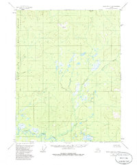
1956 Map of Black River C-2
USGS Topo · Published 1985About this map
Salmon Fork Black River dominates the southern landscape of this mid-century survey, its winding course threading through a vast network of wetlands and seasonal ponds. The area, characterized by its intricate drainage patterns, features Tetthajik Creek as a primary tributary flowing southwest across the central terrain. Based on aerial photography from 1955 and field observations from 1956, the map records the natural state of this subarctic wilderness before the formal boundary establishment of the Yukon Flats National Wildlife Refuge and Arctic NWR. The absence of roads or permanent settlements highlights the isolation of the region during the transition from the territorial era to statehood, preserving a detailed view of the hydraulic systems and unnamed topographic elevations that define the watershed.
Find a feature on this map
5 named features on this map. Tap any name to fly to it.
Don’t see what you’re looking for? This feature index may not catch every label — zoom into the map to look around manually.
Map Details
Editions of this 1956 Black River C-2 Map
3 editions found
Other maps of this area

1951 · Black River
USGS Topo · 1:250,000

1956 · Black River D-3
USGS Topo · 1:63,360

1956 · Black River B-3
USGS Topo · 1:63,360

1956 · Black River B-2
USGS Topo · 1:63,360

1956 · Black River B-1
USGS Topo · 1:63,360

1956 · Black River C-2
USGS Topo · 1:63,360

1956 · Black River D-2
USGS Topo · 1:63,360
1956 · Black River C-1
USGS Topo · 1:63,360
1956 · Black River D-1
USGS Topo · 1:63,360

1956 · Black River C-3
USGS Topo · 1:63,360