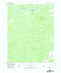
1956 Map of Black River D-4
USGS Topo · Published 1984About this map
The Lower Porcupine River winds through the northern reaches of this interior Alaskan landscape, defining the topography of the Ramparts. Surveyed in the mid-1950s, the terrain is marked by high elevations such as Negrohead Mountain in the southeast and Frozen Calf Mountain to the west. This area, largely unsurveyed and unmarked at the time of mapping, shows almost no human infrastructure save for a solitary cabin situated along the riverbank near the bend of the Porcupine.
Find a feature on this map
10 named features on this map. Tap any name to fly to it.
Don’t see what you’re looking for? This feature index may not catch every label — zoom into the map to look around manually.
Map Details
Editions of this 1956 Black River D-4 Map
4 editions found
Other maps of this area

1951 · Black River
USGS Topo · 1:250,000

1951 · Coleen
USGS Topo · 1:250,000

1956 · Coleen
USGS Topo · 1:250,000

1956 · Black River D-3
USGS Topo · 1:63,360

1956 · Coleen A-5
USGS Topo · 1:63,360

1956 · Black River D-4
USGS Topo · 1:63,360

1956 · Black River D-5
USGS Topo · 1:63,360

1956 · Coleen A-3
USGS Topo · 1:63,360

1956 · Black River C-5
USGS Topo · 1:63,360

1956 · Black River C-4
USGS Topo · 1:63,360