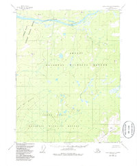
1956 Map of Black River D-4
USGS Topo · Published 1985About this map
Porcupine River carves a deep path through the northern landscape of this interior Alaska survey, where the water flows through the dramatic Lower Ramparts. This 1956 topography, updated in the mid-1980s, documents the sprawling wetlands of the Yukon Flats within the vast boundaries of the Arctic National Wildlife Refuge. The map reveals a wild, unpopulated territory where geography is defined by high elevations like Negrohead Mountain and Frozen Calf Mountain. To the northeast, Rat Creek drains toward the main river channel, winding through a complex network of small lakes and ponds that dominate the central flats. The lack of roads or settlements emphasizes the remote nature of this wilderness at the time of the survey, serving as a primary record of the drainage patterns and peaks that define this subarctic environment.
Find a feature on this map
7 named features on this map. Tap any name to fly to it.
Don’t see what you’re looking for? This feature index may not catch every label — zoom into the map to look around manually.
Map Details
Editions of this 1956 Black River D-4 Map
4 editions found
Other maps of this area

1951 · Black River
USGS Topo · 1:250,000

1951 · Coleen
USGS Topo · 1:250,000

1956 · Coleen
USGS Topo · 1:250,000

1956 · Black River D-3
USGS Topo · 1:63,360

1956 · Coleen A-5
USGS Topo · 1:63,360

1956 · Black River D-4
USGS Topo · 1:63,360

1956 · Black River D-5
USGS Topo · 1:63,360

1956 · Coleen A-3
USGS Topo · 1:63,360

1956 · Black River C-5
USGS Topo · 1:63,360

1956 · Black River C-4
USGS Topo · 1:63,360