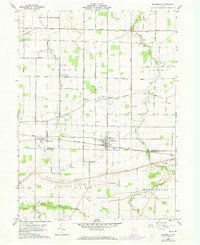
1960 Map of Bloomdale
USGS Topo · Published 1973About this map
Bloomdale serves as the focal point of this Northwest Ohio landscape, situated at the junction of the Baltimore and Ohio railroad and several primary local thoroughfares. The 1960s terrain is marked by a grid of agricultural fields and a notable network of energy infrastructure, including a prominent Tank Farm in the north and several pipelines traversing the townships of Bloom, Perry, Cass, and Washington. Small agricultural hubs like Bairdstown and Eagleville are clearly delineated, showing the residential clusters that supported the local farming economy. Natural drainage is provided by the South Branch Portage River and Rocky Ford, which wind through the rural landscape. For genealogists, the map identifies several local burial sites including Weaver Cem, Chapel Cem, and Ark Cem, which are vital markers of the area's early family history and settlement patterns.
Find a feature on this map
45 named features on this map. Tap any name to fly to it.
Don’t see what you’re looking for? This feature index may not catch every label — zoom into the map to look around manually.
Map Details
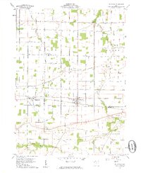
Editions of this 1960 Bloomdale Map
3 editions found

Other maps of this area

1901 · Fostoria
USGS Topo · 1:62,500

1901 · Bowling Green
USGS Topo · 1:62,500

1901 · Elmore
USGS Topo · 1:62,500

1903 · Bowling Green
USGS Topo · 1:62,500

1903 · Fostoria
USGS Topo · 1:62,500

1903 · Findlay
USGS Topo · 1:62,500

1903 · Elmore
USGS Topo · 1:62,500

1956 · Toledo
USGS Topo · 1:250,000

1958 · Jerry City
USGS Topo · 1:24,000

1958 · Bowling Green South
USGS Topo · 1:24,000