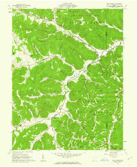
1961 Map of Blue Creek
USGS Topo · Published 1962About this map
Shawnee State Forest dominates this section of the Virginia Military District, where the winding valley of Scioto Brush Creek separates several prominent ridges. The small community of Blue Creek serves as a local hub, home to the Township High Sch and St Josephs Ch. The landscape is characterized by narrow hollows and runs, such as Coon Hollow and Walker Run, which historically dictated the placement of family homesteads and small burial grounds like Cassel Cem and Copas Cem.
Find a feature on this map
64 named features on this map. Tap any name to fly to it.
Don’t see what you’re looking for? This feature index may not catch every label — zoom into the map to look around manually.
Map Details
Editions of this 1961 Blue Creek Map
Other maps of this area

1915 · Garrison
USGS Topo · 1:62,500

1915 · Otway
USGS Topo · 1:62,500

1916 · Peebles
USGS Topo · 1:62,500

1917 · Otway
USGS Topo · 1:62,500

1918 · Garrison
USGS Topo · 1:62,500

1918 · Peebles
USGS Topo · 1:62,500

1919 · Vanceburg
USGS Topo · 1:62,500

1949 · Pond Run
USGS Topo · 1:24,000

1949 · Vanceburg
USGS Topo · 1:62,500

1949 · Buena Vista
USGS Topo · 1:24,000