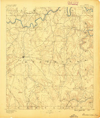
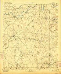
1890 Map of Breckenridge
USGS Topo · Published 1897About this map
The Breckenridge settlement serves as the central hub of this survey, surrounded by a landscape defined by the winding course of the Clear Fork of Brazos River and its numerous tributaries. Surveyed in 1888, the map reveals a network of early frontier communities including Crystal Falls, Eliasville, and the remote outposts of Gunsight and Wayland. The terrain is punctuated by distinctive family-named and descriptive landmarks such as Steal Easy Mt., Bald Mt., and Spy Mt., which guided early travelers across this portion of north-central Texas. In the southern reach, the Texas and Pacific railroad line cuts through the corner of the sheet, providing a vital link to the cattle and emerging coal interests indicated by the presence of Carbondale near the northern boundary. The intricate drainage patterns of Hubbard Creek and Caddo Creek illustrate the natural corridors that influenced the location of these early Stephens County settlements.
Find a feature on this map
61 named features on this map. Tap any name to fly to it.
Don’t see what you’re looking for? This feature index may not catch every label — zoom into the map to look around manually.
Map Details
Editions of this 1890 Breckenridge Map
6 editions found
Other maps of this area

1890 · Stephenville
USGS Topo · 1:125,000

1890 · Breckenridge
USGS Topo · 1:125,000

1891 · Palo Pinto
USGS Topo · 1:125,000

1892 · Albany
USGS Topo · 1:125,000

1893 · Albany
USGS Topo · 1:125,000

1894 · Eastland
USGS Topo · 1:125,000

1918 · Palo Pinto
USGS Topo · 1:125,000

1920 · Stephenville
USGS Topo · 1:125,000

1924 · Breckenridge 1-a
USGS Topo · 1:48,000

1924 · Palo Pinto 2-b
USGS Topo · 1:48,000