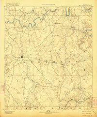
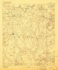
1890 Map of Breckenridge
USGS Topo · Published 1922About this map
Breckenridge stands as the central hub of this North Texas cattle and ranching country, captured just before the 1920s oil boom would fundamentally reshape the regional economy. The landscape is defined by the winding course of the Clear Fork of Brazos River, which cuts through the northern reaches near Eliasville and Crystal Falls. These early settlements were established along the river for water access, while the southern portion of the map shows the influence of early rail transportation with the Texas and Pacific RR crossing the southeast corner near Evensville Peak.
Find a feature on this map
63 named features on this map. Tap any name to fly to it.
Don’t see what you’re looking for? This feature index may not catch every label — zoom into the map to look around manually.
Map Details
Editions of this 1890 Breckenridge Map
6 editions found
Other maps of this area

1890 · Stephenville
USGS Topo · 1:125,000

1890 · Breckenridge
USGS Topo · 1:125,000

1891 · Palo Pinto
USGS Topo · 1:125,000

1892 · Albany
USGS Topo · 1:125,000

1893 · Albany
USGS Topo · 1:125,000

1894 · Eastland
USGS Topo · 1:125,000

1918 · Palo Pinto
USGS Topo · 1:125,000

1920 · Stephenville
USGS Topo · 1:125,000

1924 · Breckenridge 1-a
USGS Topo · 1:48,000

1924 · Palo Pinto 2-b
USGS Topo · 1:48,000