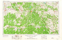
1954 Map of Brownwood
USGS Topo · Published 1965About this map
Pecan Bayou and the Colorado River serve as the primary drainage systems for this expansive region of Central Texas, where ranching and early petroleum development shaped the mid-century landscape. The map captures the significant water management efforts of the era, showcasing recently established impoundments like Lake Brownwood, Hords Creek Reservoir, Brady Reservoir, and the developing Proctor Reservoir. These projects reflect a transition from a strictly agrarian economy toward one supported by reliable water infrastructure for growing towns like Brownwood, Coleman, and Brady.
Find a feature on this map
140 named features on this map. Tap any name to fly to it.
Don’t see what you’re looking for? This feature index may not catch every label — zoom into the map to look around manually.
Map Details
Editions of this 1954 Brownwood Map
3 editions found

Other maps of this area

1885 · San Saba
USGS Topo · 1:125,000

1887 · Llano
USGS Topo · 1:125,000

1887 · Lampasas
USGS Topo · 1:125,000

1887 · Mason
USGS Topo · 1:125,000

1887 · Burnet
USGS Topo · 1:125,000

1887 · Coleman
USGS Topo · 1:125,000

1888 · Hamilton
USGS Topo · 1:125,000

1888 · Meridian
USGS Topo · 1:125,000

1889 · Granbury
USGS Topo · 1:125,000

1889 · Brownwood
USGS Topo · 1:125,000