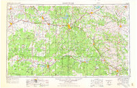
1954 Map of Brownwood
USGS Topo · Published 1976About this map
The rolling Edwards Plateau and the Cross Timbers region meet in this mid-century survey of Central Texas. Lake Brownwood and Lake Brownwood State Park serve as central landmarks, with the surrounding landscape marked by the deep incision of the Colorado River and the San Saba River. The map reveals an economy defined by cattle ranching and the expansion of the energy sector, noted by several oil fields and quarries scattered throughout Coleman County and McCulloch County.
Find a feature on this map
137 named features on this map. Tap any name to fly to it.
Don’t see what you’re looking for? This feature index may not catch every label — zoom into the map to look around manually.
Map Details
Editions of this 1954 Brownwood Map
3 editions found

Other maps of this area

1885 · San Saba
USGS Topo · 1:125,000

1887 · Llano
USGS Topo · 1:125,000

1887 · Lampasas
USGS Topo · 1:125,000

1887 · Mason
USGS Topo · 1:125,000

1887 · Burnet
USGS Topo · 1:125,000

1887 · Coleman
USGS Topo · 1:125,000

1888 · Hamilton
USGS Topo · 1:125,000

1888 · Meridian
USGS Topo · 1:125,000

1889 · Granbury
USGS Topo · 1:125,000

1889 · Brownwood
USGS Topo · 1:125,000