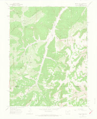
1964 Map of Brushy Point
USGS Topo · Published 1968About this map
Brushy Point and Scare Mountain anchor this 1964 survey of the high plateau country along the boundary of Rio Blanco and Garfield Counties. The landscape is defined by a dense network of drainages including East Douglas Creek and Gillam Draw, illustrating the complex erosion patterns of the Piceance Basin. Settlement is sparse, represented by a singular Jeep Trail that winds through the canyon bottoms and across the ridges.
Find a feature on this map
30 named features on this map. Tap any name to fly to it.
Don’t see what you’re looking for? This feature index may not catch every label — zoom into the map to look around manually.
Map Details
Editions of this 1964 Brushy Point Map
4 editions found
Other maps of this area

1956 · Grand Junction
USGS Topo · 1:250,000

1959 · Grand Junction
USGS Topo · 1:250,000

1960 · Grand Junction
USGS Topo · 1:250,000

1962 · Grand Junction
USGS Topo · 1:250,000

1964 · Grand Junction
USGS Topo · 1:250,000

1964 · Douglas Pass
USGS Topo · 1:24,000

1964 · Brushy Point
USGS Topo · 1:24,000

1964 · Henderson Ridge
USGS Topo · 1:24,000

1964 · Black Cabin Gulch
USGS Topo · 1:24,000
1964 · White Coyote Draw
USGS Topo · 1:24,000