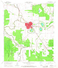
1965 Map of Bunkie
USGS Topo · Published 1967About this map
The intersection of the Texas and Pacific and Southern Pacific railroads anchors the regional hub of Bunkie, where the town's grid reflects a busy mid-century interior economy. This 1965 survey shows the transition from the dense street plan of Bunkie, including the Carver High Sch and St Anthony Sch, to the surrounding agricultural and industrial landscape. The extraction economy is prominent in the southwest with the Eola Oil and Gas Field and Haas Oil and Gas Field. Rural life is centered around small settlements like Homesville and several country churches including Booneville Ch and Second Union Ch. The topography is defined by the winding Bayou Boeuf and the engineered Bayou Boeuf Cocodrie Diversion Channel, which manage water across the flat terrain of the Avoyelles Parish lowlands.
Find a feature on this map
45 named features on this map. Tap any name to fly to it.
Don’t see what you’re looking for? This feature index may not catch every label — zoom into the map to look around manually.
Map Details
Editions of this 1965 Bunkie Map
3 editions found
Other maps of this area

1935 · Turkey Creek
USGS Topo · 1:62,500

1935 · Lecompte
USGS Topo · 1:62,500

1940 · Marksville
USGS Topo · 1:62,500

1948 · Bunkie
USGS Topo · 1:62,500

1949 · Turkey Creek
USGS Topo · 1:62,500

1952 · Lake Charles
USGS Topo · 1:250,000

1953 · Alexandria
USGS Topo · 1:250,000

1954 · Lake Charles
USGS Topo · 1:250,000

1955 · Alexandria
USGS Topo · 1:250,000

1957 · Lecompte
USGS Topo · 1:62,500