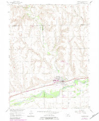
1956 Map of Cambridge
USGS Topo · Published 1983About this map
Republican River valley life in southwest Nebraska centers on the town of Cambridge, where the local landscape is defined by the confluence of major waterways and transport lines. The 1950s infrastructure shows a community tied to the land and its resources, featuring the Burlington Northern railroad running parallel to the Red Willow Canal. North of the town center, the Cambridge Municipal Airport and a series of deep drainages like Medicine Creek and Little Medicine Creek break up the high plains terrain.
Find a feature on this map
21 named features on this map. Tap any name to fly to it.
Don’t see what you’re looking for? This feature index may not catch every label — zoom into the map to look around manually.
Map Details
Editions of this 1956 Cambridge Map
3 editions found
Other maps of this area

1954 · McCook
USGS Topo · 1:250,000

1956 · Freedom
USGS Topo · 1:24,000

1956 · Cambridge
USGS Topo · 1:24,000

1956 · Medicine Creek Dam
USGS Topo · 1:24,000

1956 · Bartley
USGS Topo · 1:24,000

1957 · McCook
USGS Topo · 1:250,000

1957 · Danbury NE
USGS Topo · 1:24,000

1958 · McCook
USGS Topo · 1:250,000

1958 · Danbury NE
USGS Topo · 1:24,000
1958 · Wilsonville NW
USGS Topo · 1:24,000