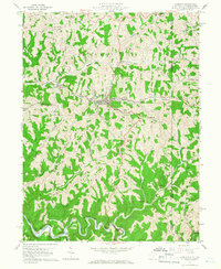
1960 Map of Cameron
USGS Topo · Published 1966About this map
The Baltimore and Ohio railroad corridor serves as the industrial spine of this region, winding through the valley of Grave Creek and passing through the Welling Tunnel near Tunnel Hill. The settlement of Cameron sits at the heart of this activity, supported by local infrastructure like the Water Works and a High School. The landscape is defined by its complex ridge-and-valley system, with Fork Ridge and Cameron Ridge looming over numerous runs and creeks. To the south, the deep meanders of Fish Creek are marked by a localized Gas Field and a concentration of Oil Wells. Away from the rail line, rural life is centered around small communities such as Loudonville, Woodruff, and Bellton, alongside quiet landmarks like Mount Carmel church and cemetery. The border between West Virginia and Pennsylvania runs along the eastern edge, bisecting properties near Rocklick.
Find a feature on this map
59 named features on this map. Tap any name to fly to it.
Don’t see what you’re looking for? This feature index may not catch every label — zoom into the map to look around manually.
Map Details
Editions of this 1960 Cameron Map
4 editions found
Other maps of this area

1903 · Littleton
USGS Topo · 1:62,500

1904 · Cameron
USGS Topo · 1:62,500

1905 · Mannington
USGS Topo · 1:62,500

1905 · Rogersville
USGS Topo · 1:62,500

1905 · Littleton
USGS Topo · 1:62,500

1923 · Mannington
USGS Topo · 1:62,500

1924 · Littleton
USGS Topo · 1:62,500

1926 · Littleton
USGS Topo · 1:62,500

1926 · Mannington
USGS Topo · 1:62,500

1935 · Cameron
USGS Topo · 1:62,500