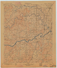
1900 Map of Canadian
USGS Topo · Published 1913About this map
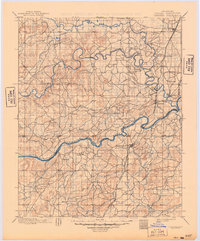
The Cherokee Nation and Choctaw Nation boundaries define this landscape in the years before Oklahoma statehood. Surveyed in the mid-1890s, the map documents the convergence of the North Fork Canadian River and the main Canadian River through a maze of creeks and wetlands like Baptising Creek and Coon Creek. The Missouri Kansas and Texas railroad cuts a north-south line through the territory, establishing critical transportation hubs at Checotah, Bond Sta, and Eufaula.
Find a feature on this map
38 named features on this map. Tap any name to fly to it.
Don’t see what you’re looking for? This feature index may not catch every label — zoom into the map to look around manually.
Map Details
Editions of this 1900 Canadian Map
6 editions found
Other maps of this area

1896 · Okmulgee
USGS Topo · 1:125,000

1896 · Coalgate
USGS Topo · 1:125,000

1898 · McAlester
USGS Topo · 1:125,000

1899 · Coalgate
USGS Topo · 1:125,000

1900 · Sansbois
USGS Topo · 1:125,000

1900 · Canadian
USGS Topo · 1:125,000

1900 · Wewoka
USGS Topo · 1:125,000

1900 · Okmulgee
USGS Topo · 1:125,000

1900 · Coalgate
USGS Topo · 1:125,000

1901 · Muscogee
USGS Topo · 1:125,000