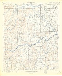
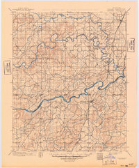
1900 Map of Canadian
USGS Topo · Published 1913About this map
The Creek Nation Cherokee Nation and Creek Nation Choctaw Nation boundaries converge in this 1890s survey, illustrating a pivotal era before Oklahoma statehood. The terrain is defined by the massive confluence of the Canadian River and the North Fork Canadian River, where the Missouri Kansas and Texas railroad corridor facilitates the growth of early regional hubs. The settlement of Eufaula stands as a primary focal point, surrounded by smaller agrarian communities such as Fishertown, Fame, and South Canadian. This mapping effort, led by topographers like Van H. Manning, meticulously tracks the winding courses of Gaines Creek and Deep Fork Canadian River, revealing a landscape where water and rail dictated the pace of development. The network of small streams, including Baptising Creek and Coon Creek, highlights the intricate drainage patterns of the Indian Territory before the later 20th-century alterations to the river system.
Find a feature on this map
41 named features on this map. Tap any name to fly to it.
Don’t see what you’re looking for? This feature index may not catch every label — zoom into the map to look around manually.
Map Details
Editions of this 1900 Canadian Map
6 editions found
Other maps of this area

1896 · Okmulgee
USGS Topo · 1:125,000

1896 · Coalgate
USGS Topo · 1:125,000

1898 · McAlester
USGS Topo · 1:125,000

1899 · Coalgate
USGS Topo · 1:125,000

1900 · Sansbois
USGS Topo · 1:125,000

1900 · Canadian
USGS Topo · 1:125,000

1900 · Wewoka
USGS Topo · 1:125,000

1900 · Okmulgee
USGS Topo · 1:125,000

1900 · Coalgate
USGS Topo · 1:125,000

1901 · Muscogee
USGS Topo · 1:125,000