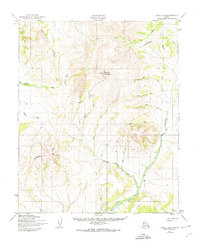
1950 Map of Candle B-5
USGS Topo · Published 1974About this map
Granite Mountain dominates this remote Seward Peninsula landscape, serving as a primary topographical anchor for a region defined by its complex drainage systems and high ridges. The Continental Divide winds through the terrain, separating the headwaters of the Kiwalik River and the Peace River. Evidence of mid-century activity is concentrated near the mountain, where a Radio Tower, a Landing Strip, and a Mine suggest a landscape geared toward resource exploration and communication. Numerous creeks, including Sweepstakes Creek, Anzac Creek, and Billy Creek, carve through the valleys between Weather Ridge and Gossan Ridge. A network of Tractor Trails provides the only visible land routes through this wilderness, connecting isolated points like a lone Cabin to the broader river systems.
Find a feature on this map
26 named features on this map. Tap any name to fly to it.
Don’t see what you’re looking for? This feature index may not catch every label — zoom into the map to look around manually.
Map Details
Editions of this 1950 Candle B-5 Map
2 editions found
Other maps of this area

1950 · Candle C-5
USGS Topo · 1:63,360

1950 · Candle A-6
USGS Topo · 1:63,360

1950 · Candle B-5
USGS Topo · 1:63,360

1950 · Candle A-5
USGS Topo · 1:63,360

1950 · Candle B-6
USGS Topo · 1:63,360

1950 · Candle C-6
USGS Topo · 1:63,360

1951 · Candle
USGS Topo · 1:250,000

1955 · Candle
USGS Topo · 1:250,000
1955 · Candle A-4
USGS Topo · 1:63,360

1955 · Candle C-4
USGS Topo · 1:63,360