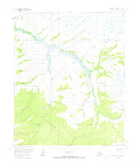
1954 Map of Candle C-2
USGS Topo · Published 1973About this map
Buckland stands as the primary settlement within this mid-century Alaskan landscape, situated where the braided waters of the South Fork Buckland River and the Middle Fork Buckland River converge. The topography is defined by the sinuous path of Kalusuk Creek and Little Kalusuk Creek, which drain the surrounding highlands including the prominent peak at Garnet. This 1954 survey, based on aerial photographs taken by the Usc&GS and Usce, illustrates a remote river-oriented geography prior to major modern developments. The Kateel River Meridian serves as the primary reference for these unsurveyed lands, where the placement of the settlement at the river fork reflects the historic importance of interior water transport for coastal access in the Northwest Arctic.
Find a feature on this map
7 named features on this map. Tap any name to fly to it.
Don’t see what you’re looking for? This feature index may not catch every label — zoom into the map to look around manually.
Map Details
Editions of this 1954 Candle C-2 Map
3 editions found
Other maps of this area

1951 · Candle
USGS Topo · 1:250,000

1954 · Candle C-2
USGS Topo · 1:63,360

1954 · Candle B-2
USGS Topo · 1:63,360
1954 · Candle D-1
USGS Topo · 1:63,360

1954 · Candle C-1
USGS Topo · 1:63,360

1954 · Candle D-2
USGS Topo · 1:63,360

1954 · Candle B-1
USGS Topo · 1:63,360

1955 · Candle
USGS Topo · 1:250,000

1955 · Candle B-3
USGS Topo · 1:63,360

1955 · Candle C-3
USGS Topo · 1:63,360