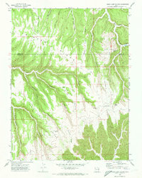
1970 Map of Cedar Camp Canyon
USGS Topo · Published 1973About this map
Winter Ridge dominates this 1970s landscape along the high plateau dividing Uintah and Grand Counties. The map documents an era of resource extraction and ranching, evidenced by the Gas Field and scattered infrastructure such as a Gas Well and several Landing Strips tucked into the high-elevation flats. The Tomlinson Ranch stands as a lonely outpost near the head of Meadow Canyon, relying on the intricate system of natural water sources like Shale Spring and Cedar Camp Spring that punctuate the deep drainages. The topography is defined by sharp elevation changes between Rock Spring Mesa and the branching canyons of Willow Creek, where a network of Jeep Trails provides the only access through the winding corridors of Cedar Camp Ridge.
Find a feature on this map
35 named features on this map. Tap any name to fly to it.
Don’t see what you’re looking for? This feature index may not catch every label — zoom into the map to look around manually.
Map Details
Editions of this 1970 Cedar Camp Canyon Map
3 editions found
Other maps of this area

1885 · East Tavaputs
USGS Topo · 1:250,000

1956 · Grand Junction
USGS Topo · 1:250,000

1959 · Grand Junction
USGS Topo · 1:250,000

1960 · Grand Junction
USGS Topo · 1:250,000

1962 · Grand Junction
USGS Topo · 1:250,000

1963 · Tenmile Canyon
USGS Topo · 1:62,500

1964 · Grand Junction
USGS Topo · 1:250,000

1965 · Grand Junction
USGS Topo · 1:250,000

1966 · Seep Canyon
USGS Topo · 1:24,000
1966 · Wolf Point
USGS Topo · 1:24,000