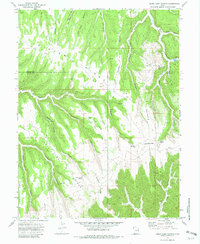
1970 Map of Cedar Camp Canyon
USGS Topo · Published 1982About this map
Winter Ridge and Asphalt Ridge dominate this corner of the High Plateaus, where the remote boundary between Uintah and Grand counties is defined by an intricate network of deep canyons and high mesas. The landscape in 1970 reflects a transition from traditional ranching to modern energy extraction. While the Tomlinson Ranch and scattered cattle-working structures like the Corral near Wire Fence Point signal the area's agricultural history, the emergence of a Gas Field and various Drill Holes mark a new industrial era. Transportation across this broken terrain was limited to a single Jeep Trail and remote Landing Strips on Willow Flats, highlighting the isolation of sites like Cedar Camp Canyon and Snowshoe Canyon. Numerous seasonal water sources, including Cedar Camp Spring and Cherry Spring, were vital for sustaining activity in this arid high-country environment.
Find a feature on this map
38 named features on this map. Tap any name to fly to it.
Don’t see what you’re looking for? This feature index may not catch every label — zoom into the map to look around manually.
Map Details
Editions of this 1970 Cedar Camp Canyon Map
3 editions found
Other maps of this area

1885 · East Tavaputs
USGS Topo · 1:250,000

1956 · Grand Junction
USGS Topo · 1:250,000

1959 · Grand Junction
USGS Topo · 1:250,000

1960 · Grand Junction
USGS Topo · 1:250,000

1962 · Grand Junction
USGS Topo · 1:250,000

1963 · Tenmile Canyon
USGS Topo · 1:62,500

1964 · Grand Junction
USGS Topo · 1:250,000

1965 · Grand Junction
USGS Topo · 1:250,000

1966 · Seep Canyon
USGS Topo · 1:24,000
1966 · Wolf Point
USGS Topo · 1:24,000