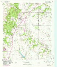
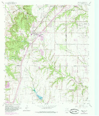
1959 Map of Cedar Hill
USGS Topo · Published 1982About this map
The growing community of Cedar Hill serves as the central hub of this survey, where the Santa Fe railroad corridor and local education at the High Sch define the local landscape. The topography transitions from the higher elevations near Inspiration Point down toward the winding course of Red Oak Creek and the southern basin of Massey Lake. This 1959 edition, updated in the early 1980s, reveals a high concentration of recreational and religious retreats, including Camp Ellowi, Cedar Hill Bible Camp, and the Mount Lebanon Encampment. These sites suggest a tradition of congregational gatherings and outdoor youth organizations in the hills southwest of Dallas. Further south across the Dallas Co Ellis Co line, rural heritage remains evident through the Shiloh Cumberland Ch and nearby Shiloh Cem, marking the settlement patterns that preceded modern suburban expansion.
Find a feature on this map
58 named features on this map. Tap any name to fly to it.
Don’t see what you’re looking for? This feature index may not catch every label — zoom into the map to look around manually.
Map Details
Editions of this 1959 Cedar Hill Map
6 editions found

Other maps of this area

1891 · Dallas
USGS Topo · 1:125,000

1891 · Cleburne
USGS Topo · 1:125,000

1893 · Dallas
USGS Topo · 1:125,000

1894 · Cleburne
USGS Topo · 1:125,000

1894 · Fort Worth
USGS Topo · 1:125,000

1954 · Dallas
USGS Topo · 1:250,000

1958 · Dallas
USGS Topo · 1:250,000

1958 · Oak Cliff
USGS Topo · 1:24,000

1959 · Arlington
USGS Topo · 1:24,000

1959 · Lancaster
USGS Topo · 1:24,000