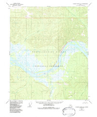
1956 Map of Charley River B-4
USGS Topo · Published 1988About this map
The confluence of the Yukon River and the Charley River dominates this interior Alaska landscape, captured during 1950s field annotations. The terrain is defined by prominent riverine features such as Biederman Bluff and Chester Bluff, which overlook the complex braiding of the Yukon. This area, later incorporated into the Yukon - Charley Rivers National Preserve, shows the extreme isolation of the territory before modern infrastructure, with only a solitary Cabin and scattered survey markers like VABM Isle and VABM Wood indicating a human footprint.
Find a feature on this map
16 named features on this map. Tap any name to fly to it.
Don’t see what you’re looking for? This feature index may not catch every label — zoom into the map to look around manually.
Map Details
Editions of this 1956 Charley River B-4 Map
Other maps of this area

1951 · Charley River
USGS Topo · 1:250,000

1956 · Charley River C-5
USGS Topo · 1:63,360

1956 · Charley River A-5
USGS Topo · 1:63,360

1956 · Charley River A-4
USGS Topo · 1:63,360

1956 · Charley River B-5
USGS Topo · 1:63,360

1956 · Charley River B-3
USGS Topo · 1:63,360

1956 · Charley River C-4
USGS Topo · 1:63,360

1956 · Charley River A-3
USGS Topo · 1:63,360
1956 · Charley River C-3
USGS Topo · 1:63,360

1956 · Charley River B-4
USGS Topo · 1:63,360