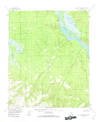
1956 Map of Charley River B-6
USGS Topo · Published 1975About this map
The Yukon River cuts a wide, braided path through this interior Alaska landscape, dominated by a complex network of drainages and high-altitude surveying points. As of the mid-1950s, the area remained largely unsettled, with the vast majority of labeled features being water bodies and terrain markers. Evidence of human activity is sparse, localized to a lone Cabin situated along the southern reaches. The topography rises sharply from the riverbanks toward peaks like Takoma Bluff, with numerous creek systems such as Thanksgiving Creek and Webber Creek carving deep into the surrounding hills. This survey records a remote wilderness defined by its hydrology and the early geodetic markers, such as VABM 2509 Webber, that served as the primary terrestrial anchors for mapping this region before widespread development or road access reached these reaches of the territory.
Find a feature on this map
13 named features on this map. Tap any name to fly to it.
Don’t see what you’re looking for? This feature index may not catch every label — zoom into the map to look around manually.
Map Details
Editions of this 1956 Charley River B-6 Map
3 editions found
Other maps of this area

1951 · Charley River
USGS Topo · 1:250,000

1951 · Circle
USGS Topo · 1:250,000

1955 · Circle A-1
USGS Topo · 1:63,360

1955 · Circle B-1
USGS Topo · 1:63,360

1955 · Circle C-1
USGS Topo · 1:63,360

1955 · Circle
USGS Topo · 1:250,000

1956 · Charley River C-5
USGS Topo · 1:63,360

1956 · Charley River C-6
USGS Topo · 1:63,360

1956 · Charley River B-6
USGS Topo · 1:63,360

1956 · Charley River A-5
USGS Topo · 1:63,360