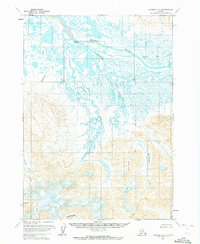
1963 Map of Chignik C-2
USGS Topo · Published 1972About this map
Meshik River dominates the northern reaches of this landscape, its waters winding through a complex system of marshes and smaller tributaries. Near a bend in the main channel, Scottys Island and a cluster of Cabins suggest a focal point for seasonal or subsistence activity in this wilderness. The terrain shifts dramatically to the south, rising toward the prominent heights of Big Butte and the dramatic topography of Cathedral Cr. This area is defined by its drainage patterns, with appropriately named features like Braided Creek and Landlocked Creek illustrating the hydrologic character of the peninsula. Along the southern edge, Thompson Val provides a level break among the steeper slopes, marking a transition between the coastal lowlands and the interior highlands.
Find a feature on this map
14 named features on this map. Tap any name to fly to it.
Don’t see what you’re looking for? This feature index may not catch every label — zoom into the map to look around manually.
Map Details
Editions of this 1963 Chignik C-2 Map
2 editions found
Other maps of this area

1963 · Chignik B-2
USGS Topo · 1:63,360

1963 · Chignik C-3
USGS Topo · 1:63,360

1963 · Chignik B-1
USGS Topo · 1:63,360

1963 · Chignik C-1
USGS Topo · 1:63,360

1963 · Chignik D-3
USGS Topo · 1:63,360

1963 · Chignik C-2
USGS Topo · 1:63,360

1963 · Chignik B-3
USGS Topo · 1:63,360

1963 · Chignik
USGS Topo · 1:250,000

1963 · Chignik D-1
USGS Topo · 1:63,360

1963 · Chignik D-2
USGS Topo · 1:63,360